
Mapa topográfico Gasherbrum II
Mapa interactivo
Haga clic en el mapa para ver la altitud.
Acerca de este mapa
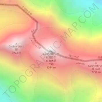
Nombre: Mapa topográfico Gasherbrum II, altitud, relieve.
Altitud media: 7.098 m
Altitud mínima: 5.846 m
Altitud máxima: 7.992 m
Gasherbrum II is located on the border of Gilgit–Baltistan, Pakistan, and Xinjiang, China. It is part of the Karakoram mountain range in the Himalayas, and located at the top of the Baltoro Glacier. With an elevation of 8,034 metres (26,358 ft) it is the third-highest member of the Gasherbrum group, behind Gasherbrum I (8,080 metres or 26,510 feet) and Broad Peak (8,051 metres or 26,414 feet). Gasherbrum III is sometimes considered to be a subpeak of Gasherbrum II, because the former has a topographic prominence of only 461 metres (1,512 ft).
Otros mapas topográficos
Haga clic en un mapa para ver su topografía, su altitud y su relieve.
Tashkorgan Town
China > Xinjiang > Taxkorgan Tajik Autonomous County
Tashkorgan Town, Taxkorgan Tajik Autonomous County, Kashgar Prefecture, Xinjiang, China
Altitud media: 3.109 m
Dafdar
China > Xinjiang > Taxkorgan Tajik Autonomous County
Dafdar, Taxkorgan Tajik Autonomous County, Kashgar Prefecture, Xinjiang, China
Altitud media: 4.416 m