
Mapa topográfico Alfdorf
Mapa interactivo
Haga clic en el mapa para ver la altitud.
Alfdorf
The municipality (Gemeinde) of Alfdorf lies at the easternmost extremity of the Rems-Murr district, along its border with the Ostalb district. Alfdorf is physically located in the Schurwald and Welzheim Forest, regions of the larger Swabian-Franconian Forest. Elevation above sea level in the municipal area ranges from a high of 566 meters (1,857 ft) Normalnull (NN) to a low of 307 meters (1,007 ft) NN.[2]
Acerca de este mapa
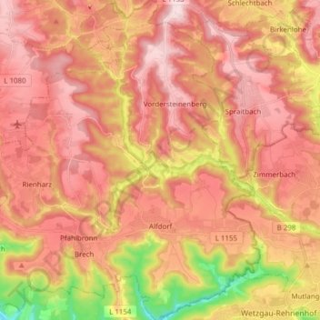
Nombre: Mapa topográfico Alfdorf, altitud, relieve.
Lugar: Alfdorf, Rems-Murr-Kreis, Baden-Württemberg, 73553, Germany (48.81434 9.63179 48.91513 9.76976)
Altitud media: 476 m
Altitud mínima: 302 m
Altitud máxima: 575 m
Otros mapas topográficos
Haga clic en un mapa para ver su topografía, su altitud y su relieve.