
Mapa topográfico Málaga
Mapa interactivo
Haga clic en el mapa para ver la altitud.
Acerca de este mapa
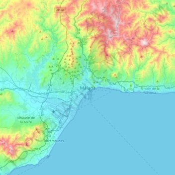
Nombre: Mapa topográfico Málaga, altitud, relieve.
Lugar: Málaga, Málaga-Costa del Sol, Malaga, Andalusia, 29008, Spain (36.56130 -4.58164 36.88130 -4.26164)
Altitud media: 215 m
Altitud mínima: -1 m
Altitud máxima: 1.019 m
Like many of the military fortifications that were constructed in Islamic Spain, the Alcazaba of Málaga featured a quadrangular plan. It was protected by an outer and inner wall, both supported by rectangular towers, between which a covered walkway led up the slope to the Gibralfaro (this was the only exchange between the two sites). Due to its rough and awkward hillside topography, corridors throughout the site provided a means of communications for administrative and defensive operations, also affording privacy to the palatial residential quarters.
Otros mapas topográficos
Haga clic en un mapa para ver su topografía, su altitud y su relieve.
Carretera de Cádiz
Spain > Andalusia > Málaga-Costa del Sol > Málaga
Carretera de Cádiz, Málaga, Málaga-Costa del Sol, Malaga, Andalusia, Spain
Altitud media: 8 m
Este
Spain > Andalusia > Málaga-Costa del Sol > Málaga
Este, Málaga, Málaga-Costa del Sol, Malaga, Andalusia, Spain
Altitud media: 423 m
Campanillas
Spain > Andalusia > Málaga-Costa del Sol > Málaga
Campanillas, Málaga, Málaga-Costa del Sol, Malaga, Andalusia, Spain
Altitud media: 108 m
Pinares de San Antón
Spain > Andalusia > Málaga-Costa del Sol > Málaga
Pinares de San Antón, Este, Málaga, Málaga-Costa del Sol, Malaga, Andalusia, Spain
Altitud media: 161 m
Centro
Spain > Andalusia > Málaga-Costa del Sol > Málaga
Centro, Málaga, Málaga-Costa del Sol, Malaga, Andalusia, Spain
Altitud media: 26 m
Puerto de la Torre
Spain > Andalusia > Málaga-Costa del Sol > Málaga
Puerto de la Torre, Málaga, Málaga-Costa del Sol, Malaga, Andalusia, Spain
Altitud media: 196 m