
Mapa topográfico Thousand Oaks
Mapa interactivo
Haga clic en el mapa para ver la altitud.
Acerca de este mapa
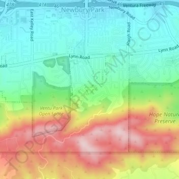
Nombre: Mapa topográfico Thousand Oaks, altitud, relieve.
Lugar: Thousand Oaks, Ventura County, California, United States (34.17084 -118.91146 34.17228 -118.90929)
Altitud media: 303 m
Altitud mínima: 191 m
Altitud máxima: 486 m
The northern parts consist of mountainous terrain in the Simi Hills, Conejo Mountains and Mount Clef Ridge. Narrow canyons such as Hill Canyon cut through the steeper mountainous areas. Conejo Mountain and Conejo Grade are found in westernmost Newbury Park, while the southernmost parts of Thousand Oaks are made up of Russell Valley, Hidden Valley and the steep rugged slopes of the Santa Monica Mountains. The elevation ranges from 500 feet in the northwest to the 2,403 feet Simi Peak. The major drainage is Conejo Creek (Arroyo Conejo).
Otros mapas topográficos
Haga clic en un mapa para ver su topografía, su altitud y su relieve.
Newbury Park
United States > California > Ventura County > Thousand Oaks
Newbury Park, Thousand Oaks, Ventura County, CAL Fire Southern Region, California, 91320, United States
Altitud media: 262 m
Thousand Oaks
United States > California > Ventura County > Thousand Oaks
Thousand Oaks, Ventura County, California, 91362, United States
Altitud media: 288 m
Greenwich Village
United States > California > Ventura County > Thousand Oaks
Greenwich Village, Thousand Oaks, Ventura County, CAL Fire Southern Region, California, 91360, United States
Altitud media: 275 m
Westlake Village
United States > California > Ventura County > Thousand Oaks
Westlake Village, Thousand Oaks, Ventura County, CAL Fire Southern Region, California, 91361, United States
Altitud media: 305 m
Ventu Park
United States > California > Ventura County > Thousand Oaks > Newbury Park
Ventu Park, Newbury Park, Thousand Oaks, Ventura County, CAL Fire Southern Region, California, 91320, United States
Altitud media: 250 m