
Mapa topográfico Brian Head
Mapa interactivo
Haga clic en el mapa para ver la altitud.
Acerca de este mapa
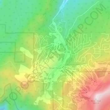
Nombre: Mapa topográfico Brian Head, altitud, relieve.
Lugar: Brian Head, Iron County, Utah, 84719, United States (37.67687 -112.86085 37.71835 -112.81521)
Altitud media: 3.031 m
Altitud mínima: 2.729 m
Altitud máxima: 3.449 m
The community, at an elevation of 9,800 feet (3,000 m) above sea level, is the highest town in Utah. It is located on State Route 143 and is east of Interstate 15. Brian Head is approximately three miles north of Cedar Breaks National Monument.