
Mapa topográfico Antofalla
Mapa interactivo
Haga clic en el mapa para ver la altitud.
Acerca de este mapa
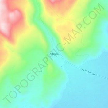
Nombre: Mapa topográfico Antofalla, altitud, relieve.
Altitud media: 3.482 m
Altitud mínima: 3.344 m
Altitud máxima: 3.775 m
Antofalla and other Andean volcanoes form because the Nazca Plate is subducting beneath the South American Plate. Antofalla volcano is located in a region with a "basins and ranges" topography, where during the Miocene ranges were uplifted and basins formed through tectonic movement. It sits on a basement formed by Eocene-Miocene sedimentary units over a much older crystalline basement.