Mapa topográfico Caleb Smith State Park
Mapa interactivo
Haga clic en el mapa para ver la altitud.
Acerca de este mapa
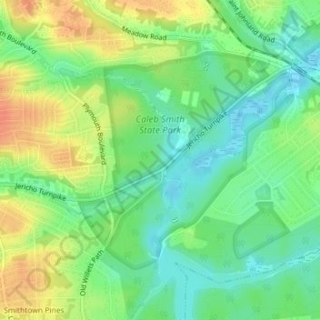
Nombre: Mapa topográfico Caleb Smith State Park, altitud, relieve.
Altitud media: 21 m
Altitud mínima: 2 m
Altitud máxima: 45 m

Haga clic en el mapa para ver la altitud.
Nombre: Mapa topográfico Caleb Smith State Park, altitud, relieve.
Altitud media: 21 m
Altitud mínima: 2 m
Altitud máxima: 45 m