
Mapa topográfico Colby
Mapa interactivo
Haga clic en el mapa para ver la altitud.
Acerca de este mapa
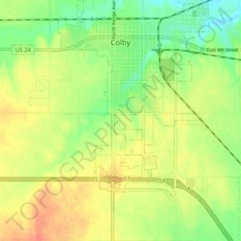
Nombre: Mapa topográfico Colby, altitud, relieve.
Lugar: Colby, Thomas County, Kansas, 67701, United States (39.35076 -101.07105 39.40552 -101.00097)
Altitud media: 970 m
Altitud mínima: 946 m
Altitud máxima: 992 m
Colby is located at 39°23′32″N 101°02′51″W / 39.392093°N 101.047532°W / 39.392093; -101.047532 (39.392093, -101.047532) at an elevation of 3,159 feet (963 m). It lies on the south side of Prairie Dog Creek, a tributary of the Republican River, in the High Plains region of the Great Plains. A small tributary of the creek flows northeast through the town. Located at the interchange of Interstate 70 and K-25 in northwestern Kansas, Colby is 212 mi (341 km) east-southeast of Denver, 232 mi (373 km) northwest of Wichita, and 347 mi (558 km) west of Kansas City.
Otros mapas topográficos
Haga clic en un mapa para ver su topografía, su altitud y su relieve.
Great Plains
United States > Kansas > Thomas County
Great Plains, Thomas County, Kansas, United States
Altitud media: 1.023 m
Brewster
United States > Kansas > Thomas County
Brewster, Thomas County, Kansas, United States
Altitud media: 1.040 m