
Mapa topográfico Whitehorse
Mapa interactivo
Haga clic en el mapa para ver la altitud.
Acerca de este mapa
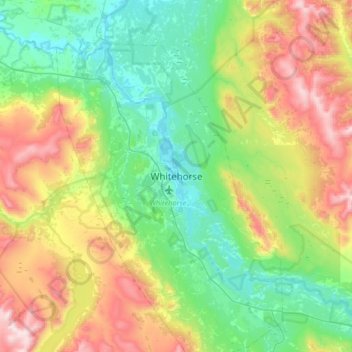
Nombre: Mapa topográfico Whitehorse, altitud, relieve.
Lugar: Whitehorse, Yukon, Canada (60.56157 -135.21493 60.88157 -134.89493)
Altitud media: 1.008 m
Altitud mínima: 629 m
Altitud máxima: 1.894 m
Whitehorse has a subarctic climate (Köppen climate classification: Dfc) and lies in the rain shadow of the Coast Mountains, causing precipitation totals to be quite low year-round. Due to the city's location in the Whitehorse valley, the climate is milder than other comparable northern communities such as Yellowknife, however during cold snaps it is not uncommon for temperatures to drop below −40 °C (−40 °F). With an average annual temperature of −0.1 °C (31.8 °F) Whitehorse is the warmest place in the Yukon. The temperature measurements for the city are taken at the airport. The Whitehorse Riverdale weather station situated at a lower elevation than the airport is even warmer at 0.2 °C (32.4 °F).
Otros mapas topográficos
Haga clic en un mapa para ver su topografía, su altitud y su relieve.
Kluane National Park and Reserve
Kluane National Park and Reserve, Yukon, Canada
Altitud media: 1.536 m
Two Mile Village
Canada > Yukon > Watson Lake
Two Mile Village, Watson Lake, Yukon, Y0A 1C0, Canada
Altitud media: 703 m
Destruction Bay
Canada > Yukon > Destruction Bay
Destruction Bay, Yukon, Y0B 1H0, Canada
Altitud media: 893 m
Dawson City
Canada > Yukon > Dawson City > Dawson City
Dawson City, Yukon, Y0B 1G0, Canada
Altitud media: 510 m
Yukon, Unorganized
City of Whitehorse, Yukon, Unorganized, Yukon, Canada
Altitud media: 1.010 m
Swift River
Canada > Yukon > Swift River
Swift River, Yukon, Unorganized, Yukon, Canada
Altitud media: 1.086 m