
Gracias por apoyar a este sitio ❤️
Haz una donación
Haz una donación
Mapa topográfico Islas Malvinas
Haga clic en el mapa para ver la altitud.
Gracias por apoyar a este sitio ❤️
Haz una donación
Haz una donación
Acerca de este mapa
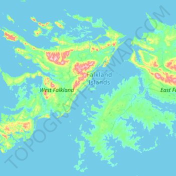
Nombre: Mapa topográfico Islas Malvinas, altitud, relieve.
Lugar: Islas Malvinas, Falkland Islands (-52.42360 -60.28467 -51.14360 -59.00467)
Altitud media: 34 m
Altitud mínima: -1 m
Altitud máxima: 698 m
Gracias por apoyar a este sitio ❤️
Haz una donación
Haz una donación
Otros mapas topográficos
Haga clic en un mapa para ver su topografía, su altitud y su relieve.
Gracias por apoyar a este sitio ❤️
Haz una donación
Haz una donación
Gracias por apoyar a este sitio ❤️
Haz una donación
Haz una donación
Gracias por apoyar a este sitio ❤️
Haz una donación
Haz una donación
Beaver Island
Other islands in the group include Staats Island, with an area of 500 hectares (1,200 acres); Tea Island, which covers 310 hectares (770 acres); Governor Island, which covers 220 hectares (540 acres); Split Island, with an area of 70 hectares (170 acres) and a few smaller islands. Though the smaller islands in…
Altitud media: 24 m
Gracias por apoyar a este sitio ❤️
Haz una donación
Haz una donación