
Gracias por apoyar a este sitio ❤️
Haz una donación
Haz una donación
Mapa topográfico Stockstadt am Rhein
Haga clic en el mapa para ver la altitud.
Gracias por apoyar a este sitio ❤️
Haz una donación
Haz una donación
Stockstadt am Rhein
Stockstadt liegt in der Oberrheinischen Tiefebene an der Schleife des Stockstadt-Erfelder Altrheins, dem Europareservat Kühkopf-Knoblochsaue gegenüber, in Höhe der Mündung der Modau in den Rhein, am südlichen Rand des Rhein-Main-Gebiets.
Gracias por apoyar a este sitio ❤️
Haz una donación
Haz una donación
Acerca de este mapa
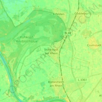
Nombre: Mapa topográfico Stockstadt am Rhein, altitud, relieve.
Altitud media: 89 m
Altitud mínima: 80 m
Altitud máxima: 96 m
Gracias por apoyar a este sitio ❤️
Haz una donación
Haz una donación
Otros mapas topográficos
Haga clic en un mapa para ver su topografía, su altitud y su relieve.