
Mapa topográfico Hensonville
Mapa interactivo
Haga clic en el mapa para ver la altitud.
Acerca de este mapa
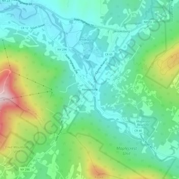
Nombre: Mapa topográfico Hensonville, altitud, relieve.
Altitud media: 585 m
Altitud mínima: 462 m
Altitud máxima: 909 m
Otros mapas topográficos
Haga clic en un mapa para ver su topografía, su altitud y su relieve.
Brooksburg
United States > New York > Greene County > Town of Windham
Brooksburg, Town of Windham, Greene County, New York, 12439, United States
Altitud media: 565 m
Maplecrest
United States > New York > Greene County > Town of Windham
Maplecrest, Town of Windham, Greene County, New York, 12454, United States
Altitud media: 625 m
Blackhead
United States > New York > Greene County > Town of Windham
Blackhead, Town of Windham, Greene County, New York, United States
Altitud media: 893 m