
Mapa topográfico Lewis Smith Lake
Mapa interactivo
Haga clic en el mapa para ver la altitud.
Acerca de este mapa
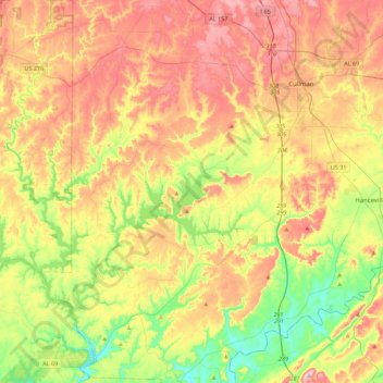
Nombre: Mapa topográfico Lewis Smith Lake, altitud, relieve.
Lugar: Lewis Smith Lake, Winston County, Alabama, United States (33.94207 -87.35736 34.19799 -86.91052)
Altitud media: 208 m
Altitud mínima: 82 m
Altitud máxima: 349 m
Otros mapas topográficos
Haga clic en un mapa para ver su topografía, su altitud y su relieve.
Haleyville
United States > Alabama > Winston County
Haleyville, Winston County, Alabama, 35565, United States
Altitud media: 261 m
William B. Bankhead National Forest
United States > Alabama > Winston County
William B. Bankhead National Forest, Winston County, Alabama, United States
Altitud media: 232 m
Wilson Bend
United States > Alabama > Winston County > Wilson Bend
Wilson Bend, Winston County, Alabama, United States
Altitud media: 175 m
Arley
United States > Alabama > Winston County
Arley, Winston County, Alabama, United States
Altitud media: 209 m
Natural Bridge
United States > Alabama > Winston County
Natural Bridge, Winston County, Alabama, 35577, United States
Altitud media: 219 m
Double Springs
United States > Alabama > Winston County
Double Springs, Winston County, Alabama, 35553, United States
Altitud media: 226 m