
Mapa topográfico Banff National Park
Mapa interactivo
Haga clic en el mapa para ver la altitud.
Acerca de este mapa
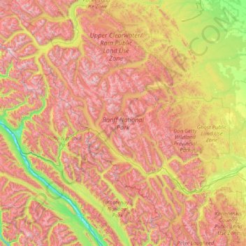
Nombre: Mapa topográfico Banff National Park, altitud, relieve.
Lugar: Banff National Park, Division No. 15, Alberta, Canada (50.70506 -117.31712 52.27145 -115.16491)
Altitud media: 1.848 m
Altitud mínima: 773 m
Altitud máxima: 3.472 m
Banff National Park has a subarctic climate with three ecoregions, including montane, subalpine, and alpine. The forests are dominated by Lodgepole pine at lower elevations and Engelmann spruce in higher ones below the treeline, above which is primarily rocks and ice. Mammal species such as the grizzly bear, cougar, wolverine, elk, bighorn sheep and moose are found, along with hundreds of bird species. Reptiles and amphibians are also found but only a limited number of species have been recorded.
Otros mapas topográficos
Haga clic en un mapa para ver su topografía, su altitud y su relieve.
Moraine Lake
Canada > Alberta > Division No. 15
Moraine Lake, Division No. 15, Alberta, Canada
Altitud media: 2.101 m
Jasper National Park
Canada > Alberta > Division No. 15
Jasper National Park, Division No. 15, Alberta, Canada
Altitud media: 1.782 m
Toronto Peak
Canada > Alberta > Division No. 15
Toronto Peak, Division No. 15, Alberta, Canada
Altitud media: 2.423 m
Lake Louise
Canada > Alberta > Division No. 15
Lake Louise, Division No. 15, Alberta, Canada
Altitud media: 1.617 m