
Mapa topográfico Storrington
Haga clic en el mapa para ver la altitud.
Acerca de este mapa
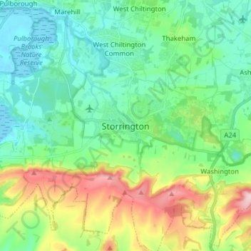
Nombre: Mapa topográfico Storrington, altitud, relieve.
Altitud media: 65 m
Altitud mínima: -3 m
Altitud máxima: 231 m
Otros mapas topográficos
Haga clic en un mapa para ver su topografía, su altitud y su relieve.
South Downs National Park
United Kingdom > England > West Sussex
The South Downs National Park's chalk downland is a feature that sets it apart from other national parks in Britain. However, almost a quarter (23%) of the national park consists of a quite different and strongly contrasting physiographic region, the western Weald, whose densely wooded hills and vales are…
Altitud media: 54 m
Crawley
United Kingdom > England > West Sussex
Crawley lies within the Sussex Weald, an area of highly variable terrain so that many microclimates of frost hollows, sun traps and windswept hilltops will be encountered over a short distance. During calm, clear periods of weather this allows for some interesting temperature variations, although most of the…
Altitud media: 80 m
Selsey
United Kingdom > England > West Sussex > Chichester
A study published by Princeton University and McGill University, in 2020, concluded that the Manhood Peninsula is at particularly high risk of flooding as its topography is less than 5 metres (16 ft) above the current mean sea level and that by 2100 Selsey will be subject to permanent inundation.
Altitud media: 1 m
West Wittering
United Kingdom > England > West Sussex > Chichester > West Wittering
Altitud media: 2 m
Washington Common
United Kingdom > England > West Sussex > Storrington > Washington
Altitud media: 61 m
Harting
United Kingdom > England > West Sussex > Chichester > South Harting
Because of its elevation Beacon Hill, just to the east of Harting Down, hosted a station in the shutter telegraph chain, from 1796 to 1816, which connected the Admiralty in London to its naval ships in Portsmouth and Plymouth. This was replaced in 1822 by a semaphore station which operated on a slightly…
Altitud media: 101 m
Batchelors Farm Nature Conservation Site
United Kingdom > England > West Sussex > Mid Sussex District > Burgess Hill
Altitud media: 49 m
Cock Robin Wood
United Kingdom > England > West Sussex > Mid Sussex > East Grinstead > Saint Hill Green
Altitud media: 103 m