
Mapa topográfico Mammoth Cave National Park
Mapa interactivo
Haga clic en el mapa para ver la altitud.
Acerca de este mapa
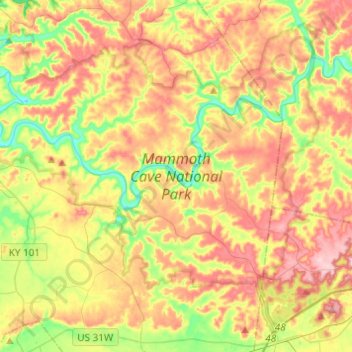
Nombre: Mapa topográfico Mammoth Cave National Park, altitud, relieve.
Altitud media: 215 m
Altitud mínima: 132 m
Altitud máxima: 300 m
The upper sandstone member is known as the Big Clifty Sandstone. Thin, sparse layers of limestone interspersed within the sandstone give rise to an epikarstic zone, in which tiny conduits (cave passages too small to enter) are dissolved by the natural acidity of groundwater. The epikarstic zone concentrates local flows of runoff into high-elevation springs which emerge at the edges of ridges. The resurgent water from these springs typically flows briefly on the surface before sinking underground again at elevation of the contact between the sandstone caprock and the underlying massive limestones. It is in these underlying massive limestone layers that the human-explorable caves of the region have naturally developed.