Geolocalizar

Mapa topográfico Norfolk

Mapa interactivo

Haga clic en el mapa para ver la altitud.

Acerca de este mapa

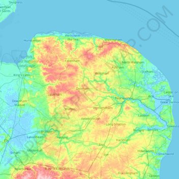
Nombre: Mapa topográfico Norfolk, altitud, relieve.

Lugar: Norfolk, England, United Kingdom (52.35534 0.15362 52.99164 1.74578)

Altitud media: 23 m

Altitud mínima: -4 m

Altitud máxima: 126 m

Otros mapas topográficos

Haga clic en un mapa para ver su topografía, su altitud y su relieve.

London

United Kingdom > England > London

Altitud media: 42 m

Leeds

United Kingdom > England

Lying in the eastern foothills of the Pennines, there is a significant variation in elevation within the city's built-up area. The district ranges from 1,115 feet (340 m) in the far west on the slopes of Ilkley Moor to about 33 feet (10 m) where the rivers Aire and Wharfe cross the eastern boundary. Land rises…

Altitud media: 94 m

York

United Kingdom > England > York

Altitud media: 21 m

Cambridge

United Kingdom > England > Cambridge

The city, like most of the UK, has a maritime climate highly influenced by the Gulf Stream. Located in the driest region of Britain, Cambridge's rainfall averages around 570 mm (22.44 in) per year, around half the national average, with some years occasionally falling into the semi-arid (under 500 mm (19.69…

Altitud media: 18 m

Huddersfield

United Kingdom > England > Kirklees

Altitud media: 145 m

Torquay

United Kingdom > England > Torbay

Altitud media: 31 m

Hull

United Kingdom > England > Kingston upon Hull

Kingston upon Hull is on the northern bank of the Humber Estuary. The city centre is west of the River Hull and close to the Humber. The city is built upon alluvial and glacial deposits which overlie chalk rocks but the underlying chalk has no influence on the topography. The land within the city is generally…

Altitud media: 21 m

Ealing

United Kingdom > England

Altitud media: 26 m

City of London

United Kingdom > England > City of London > City of London

The elevation of the City ranges from sea level at the Thames to 21.6 metres (71 ft) at the junction of High Holborn and Chancery Lane. Two small but notable hills are within the historic core, Ludgate Hill to the west and Cornhill to the east. Between them ran the Walbrook, one of the many "lost" rivers or…

Altitud media: 42 m

Carlisle

United Kingdom > England > Cumberland

Altitud media: 31 m

Walthamstow

United Kingdom > England

Altitud media: 21 m

Richmond Park

United Kingdom > England > London

Altitud media: 26 m

Derby

United Kingdom > England > Derbyshire

Altitud media: 96 m

Peterborough

United Kingdom > England > Cambridgeshire

The local topography is flat, and in some places, the land lies below sea level, for example in parts of the Fens to the east and to the south of Peterborough. Human settlement in the area began before the Bronze Age, as can be seen at the Flag Fen archaeological site to the east of the current city centre,…

Altitud media: 17 m

Hampstead Heath

United Kingdom > England > London

Altitud media: 94 m

Portsmouth

United Kingdom > England > Hampshire > Portsmouth

By road, Portsmouth lies 73.5 miles (118.3 km) from Central London, 49.5 miles (79.7 km) west of Brighton, and 22.3 miles (35.9 km) east of Southampton. Portsmouth is situated primarily on Portsea Island and is the United Kingdom's only island city, although parts of it have expanded onto the mainland. Gosport…

Altitud media: 28 m

Plymouth

United Kingdom > England > Devon > Plymouth

The River Plym, which flows off Dartmoor to the north-east, forms a smaller estuary to the east of the city called Cattewater. Plymouth Sound is protected from the sea by the Plymouth Breakwater, in use since 1814. In the Sound is Drake's Island which is seen from Plymouth Hoe, a flat public area on top of…

Altitud media: 81 m

Salisbury

United Kingdom > England > Salisbury

Bishop of Salisbury Hubert Walter was instrumental in the negotiations with Saladin during the Third Crusade, but he spent little time in his diocese prior to his elevation to archbishop of Canterbury. The brothers Herbert and Richard Poore succeeded him and began planning the relocation of the cathedral into…

Altitud media: 96 m

Reading

United Kingdom > England > Reading

Mary Russell Mitford lived in Reading for a number of years and then spent the rest of her life just outside the town at Three Mile Cross and Swallowfield. The fictional Belford Regis of her eponymous novel, first published in 1835, is largely based on Reading. Described with topographical accuracy, it is…

Altitud media: 56 m

Bromley

United Kingdom > England

Altitud media: 62 m

Fox Hollies

United Kingdom > England > Birmingham

Altitud media: 130 m

Croydon

United Kingdom > England

Several apartment developments, for instance Altitude 25 (completed 2010), have been built in recent years, and several more are being built or planned. The construction of Saffron Square, which includes a 43-storey tower, began on Wellesley Road in 2011 and was completed in 2016. Other developments with…

Altitud media: 70 m

Lintzford

United Kingdom > England > Gateshead

Altitud media: 113 m

Salcott

United Kingdom > England > Essex > Colchester > Salcott

Altitud media: 14 m

Wallasey

United Kingdom > England

Wallasey is situated at the north-east of the Wirral Peninsula, on the western side of the River Mersey and adjoining the Irish Sea. The area is approximately 9.5 km (5.9 mi) east-north-east of the Dee Estuary at Hoylake. Wallasey is at an elevation of between 0–50 m (0–164 ft) above sea level, with the…

Altitud media: 12 m

Caradon Hill

United Kingdom > England > Cornwall

Altitud media: 259 m

Bushy Park

United Kingdom > England > London

Altitud media: 12 m

Boreham

United Kingdom > England > Essex > Chelmsford

Altitud media: 34 m

Greenwich

United Kingdom > England

Altitud media: 20 m

Banbury

United Kingdom > England > Cherwell > Banbury

Altitud media: 119 m

Folkestone

United Kingdom > England > Folkestone

Altitud media: 46 m

Keswick

United Kingdom > England > Keswick

Altitud media: 223 m

Enfield

United Kingdom > England

Altitud media: 39 m

Shamley Green

United Kingdom > England > Surrey > Waverley

Altitud media: 73 m

Doublebois

United Kingdom > England > Cornwall

Altitud media: 135 m

Tregonetha

United Kingdom > England > Cornwall

Altitud media: 134 m

Durlston

United Kingdom > England > Dorset > Swanage

Altitud media: 22 m

Hyde Park

United Kingdom > England > London

"It consists of a screen of handsome fluted Ionic columns, with three carriage entrance archways, two-foot entrances, a lodge, etc. The extent of the whole frontage is about 107 ft (33 m). The central entrance has a bold projection: the entablature is supported by four columns; and the volutes of the capitals…

Altitud media: 25 m

Scafell Pike

United Kingdom > England > Cumberland

Scafell Pike (/ˈskɔːfɛl paɪk/) is the highest and the most prominent mountain in England, at an elevation of 978 metres (3,209 ft) above sea level. It is located in the Lake District National Park, in Cumbria, and is part of the Southern Fells and the Scafell massif.

Altitud media: 679 m

Halifax

United Kingdom > England > Calderdale

Topographically, Halifax is located in the south-eastern corner of the moorland region called the South Pennines. Halifax is situated about 4 miles (6 km) from the M62 motorway, close to Bradford and Huddersfield. The A641 road links the town with Brighouse, Bradford and Huddersfield. The Hebble Brook joins…

Altitud media: 195 m

Basingstoke

United Kingdom > England > Hampshire > Basingstoke and Deane

Situated in a valley through the Hampshire Downs at an average elevation of 88 metres (289 ft) Basingstoke is a major interchange between Reading, Newbury, Andover, Winchester, and Alton, and lies on the natural trade route between the southwest of England and London. The area had been something of an…

Altitud media: 110 m

St Albans

United Kingdom > England > Hertfordshire > St Albans

St Albans was an ancient borough created following the dissolution of the monastery in 1539. It consisted of the ancient parish of St Albans (also known as the Abbey parish) and parts of St Michael and St Peter. The municipal corporation was reformed by the Municipal Corporations Act 1835 and the boundary was…

Altitud media: 100 m

Bedford

United Kingdom > England > Bedford

As with the rest of the United Kingdom, Bedford has a maritime climate, with a limited range of temperatures, and generally even rainfall throughout the year. The nearest Met Office weather station to Bedford is Bedford (Thurleigh) airport, about 6.5 miles (10.5 km) north of Bedford town centre at an elevation…

Altitud media: 37 m

Durham

United Kingdom > England > County Durham

Altitud media: 119 m

Haynes Park

United Kingdom > England > London

Altitud media: 33 m

Swindon

United Kingdom > England > Swindon

Swindon has an oceanic climate (Cfb in the Köppen climate classification), like the vast majority of the British Isles, with cool winters and warm summers. The nearest official weather station is RAF Lyneham, about 10 miles (16 km) west southwest of Swindon town centre. The weather station's elevation is 145…

Altitud media: 108 m

Mark Cross

United Kingdom > England > East Sussex > Wealden

Altitud media: 132 m

Harbledown

United Kingdom > England > Kent > Canterbury

Altitud media: 41 m