Geolocalizar

Mapa topográfico County Wexford

Haga clic en el mapa para ver la altitud.

Acerca de este mapa

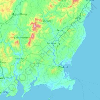
Nombre: Mapa topográfico County Wexford, altitud, relieve.

Lugar: County Wexford, Leinster, Ireland (52.10885 -7.01781 52.79745 -6.14069)

Altitud media: 63 m

Altitud mínima: -5 m

Altitud máxima: 784 m

Otros mapas topográficos

Haga clic en un mapa para ver su topografía, su altitud y su relieve.

Cork

Ireland > County Cork > Cork

Altitud media: 94 m

Maghera Strand

Ireland

Altitud media: 37 m

Galway City

Ireland > Galway City

Altitud media: 26 m

Cromane

Ireland

Altitud media: 3 m

Mizen Head

Ireland > County Cork

Altitud media: 25 m

Bettystown

Ireland > County Meath

Altitud media: 6 m

Beenkeragh

Ireland > County Kerry

Beenkeragh is the second-highest peak in Ireland, on both the Arderin and Vandeleur-Lynam lists. It is the 179th-highest mountain in Britain and Ireland on the Simm classification. Beenkeragh is regarded by the Scottish Mountaineering Club ("SMC") as one of 34 Furths, which is a mountain above 3,000 ft (914 m)…

Altitud media: 654 m

Caher

Ireland > County Kerry

Caher is the 200th–highest mountain in Britain and Ireland on the Simm classification. Caher is regarded by the Scottish Mountaineering Club ("SMC") as one of 34 Furths, which is a mountain above 3,000 ft (914.4 m) in elevation, and meets the other SMC criteria for a Munro (e.g. "sufficient separation"), but…

Altitud media: 617 m

Knocknapeasta

Ireland > County Kerry

It is the 231st-highest mountain in Britain and Ireland on the Simm classification. Cnoc na Péiste is regarded by the Scottish Mountaineering Club ("SMC") as one of 34 Furths, which is a mountain above 3,000 ft (914.4 m) in elevation, and meets the other SMC criteria for a Munro (e.g. "sufficient…

Altitud media: 579 m

Lugnaquilla

Ireland > County Wicklow

Lugnaquilla is the 432nd-highest and 21st most prominent mountain in Britain and Ireland, on the Simms classification. It is regarded by the Scottish Mountaineering Club (SMC) as one of 34 Furths, which is a mountain above 3,000 ft (914 m) in elevation, and meets the other SMC criteria for a Munro (e.g.…

Altitud media: 696 m

Baurtregaum

Ireland > County Kerry

Altitud media: 606 m

Caherconree

Ireland > County Kerry

Altitud media: 536 m

Mweelrea

Ireland > County Mayo

Altitud media: 422 m

Errigal

Ireland > County Donegal

Altitud media: 295 m

Slieve League

Ireland > County Donegal

Altitud media: 233 m

Slieve Foye

Ireland > County Louth

Altitud media: 287 m

Seefin

Ireland > County Waterford

Altitud media: 498 m

Clare

Ireland > County Galway

Altitud media: 34 m

Feale

Ireland > County Kerry

Altitud media: 47 m

Derg

Ireland > County Donegal

Altitud media: 166 m

Garavogue

Ireland > County Sligo

Altitud media: 20 m

Camlin

Ireland > County Longford > Cloonfin

Altitud media: 66 m

Doo Lough

Ireland > County Kerry

Altitud media: 20 m

Lough Dan

Ireland > County Wicklow

Altitud media: 309 m

Lough Tay

Ireland > County Wicklow

Altitud media: 395 m

Tory Island

Ireland > County Donegal

Altitud media: 3 m

Lettermore

Ireland > County Cavan

Altitud media: 90 m

Lambay Island

Ireland > County Dublin

Lambay Island is the largest island off the east coast of Ireland. It covers about 2.5 km2 (0.97 sq mi). The highest point – a hill known as Knockbane – rises to 126 m (413 ft). The island's high ground lies to the east and aside from Knockbane includes Heath Hill and Tinian Hill, and in the extreme…

Altitud media: 14 m

Great Skellig

Ireland > County Kerry

The island is of special interest to archaeologists, as the monastic settlement is in unusually good condition. The monastery on the northern peak is situated at an elevation of 170 to 180 m (550 to 600 ft), Christ's Saddle at 129 m (422 ft), and the flagstaff area are 37 m (120 ft) above sea level. The…

Altitud media: 1 m

Little Skellig

Ireland > County Kerry

Altitud media: 0 m

Spike Island

Ireland > County Cork

Altitud media: 2 m

Inishshark

Ireland > County Galway

Altitud media: 11 m

Inishbiggle

Ireland > County Mayo

Altitud media: 3 m

St Anne's Park

Ireland > County Dublin > Dublin

Altitud media: 13 m

Inis Meáin

Ireland > County Donegal

Altitud media: 1 m

Goatstown

Ireland > County Dublin

Altitud media: 58 m

Watergrasshill

Ireland > County Cork

According to A Topographical Dictionary of Ireland, published by Samuel Lewis in 1837, Watergrasshill then had a population of 533 people.

Altitud media: 164 m

Mount Brandon

Ireland > County Kerry

Altitud media: 572 m

Doolin Cave

Ireland > County Clare

Altitud media: 87 m

Cashlaundrumlahan

Ireland > County Galway

Altitud media: 310 m

Rosscahill

Ireland > County Galway

Altitud media: 36 m

Dundrum

Ireland > County Dublin

Altitud media: 79 m

Killiney Hill

Ireland > County Dublin > Killiney

Altitud media: 40 m

Annayalla

Ireland > County Monaghan

Altitud media: 123 m

Dundrum

Ireland > County Dublin

Altitud media: 79 m

Stonyford

Ireland > County Kilkenny

Altitud media: 64 m

Ward Cross

Ireland > County Dublin

Altitud media: 75 m

Clare

Ireland > County Galway

Altitud media: 30 m

Hugginstown

Ireland > County Kilkenny

Altitud media: 129 m

Scartaglen

Ireland > County Kerry

Altitud media: 133 m

Knockmore

Ireland > County Mayo

Altitud media: 108 m

Beaumont Park

Ireland > County Cork > Cork

Altitud media: 12 m

Tallaght

Ireland > County Dublin

Altitud media: 121 m

Mungret

Ireland > County Limerick > Limerick

Altitud media: 10 m

Geevagh

Ireland > County Sligo

Altitud media: 92 m

Killiney Hill

Ireland > County Dublin > Killiney

Altitud media: 40 m

Blacklion

Ireland > County Cavan

Altitud media: 92 m

Farranfore

Ireland > County Kerry

Altitud media: 59 m

Bridgetown

Ireland > County Clare

Altitud media: 68 m

Newtown Hill

Ireland > County Dublin

Altitud media: 95 m

Ballinagh

Ireland > County Cavan > Bellananagh

Altitud media: 94 m

Corlismore

Ireland > County Cavan

Altitud media: 73 m

Moneystown

Ireland > County Wicklow

Altitud media: 223 m

Ballybrown

Ireland > County Limerick > Limerick

Altitud media: 9 m

Bohermeen

Ireland > County Meath

Altitud media: 74 m

Nohoval

Ireland > County Cork

Altitud media: 56 m

Sneem

Ireland > County Kerry > Scrahanagaur

Altitud media: 27 m

Ardclough

Ireland > County Kildare

Altitud media: 76 m

Yellow

Ireland > County Kerry

Altitud media: 209 m

Blackrock

Ireland > County Louth

Altitud media: 5 m

Cornaseer

Ireland > County Cavan

Altitud media: 113 m

Knockavilla

Ireland > County Cork

Altitud media: 85 m

Harbour

Ireland > County Offaly

Altitud media: 62 m

Grangemockler

Ireland > County Tipperary

Altitud media: 165 m

Glengarriff

Ireland > County Cork

Altitud media: 66 m

Knockanore

Ireland > County Kerry

Altitud media: 155 m

Galtymore

Ireland > County Limerick > The Municipal District of Cappamore — Kilmallock

Galtymore or Galteemore (Irish: Cnoc Mór na nGaibhlte, meaning 'big hill of the Galtees') is a mountain in the province of Munster, Ireland. At 917.9 metres (3,011 ft 6 in), it is one of Ireland's highest mountains, being the 12th-highest on the Arderin list, and 14th-highest on the Vandeleur-Lynam list.…

Altitud media: 594 m

Waterfall

Ireland > County Cork

Altitud media: 83 m

Newtown Forbes

Ireland > County Longford

Altitud media: 56 m

Drimoleague

Ireland > County Cork

Altitud media: 89 m

Bannow Bay

Ireland

Altitud media: 11 m

Blackrock

Ireland > County Dublin

Altitud media: 30 m