
Haz una donación
Mapa topográfico Lake Winnipeg
Haga clic en el mapa para ver la altitud.
Haz una donación
Acerca de este mapa
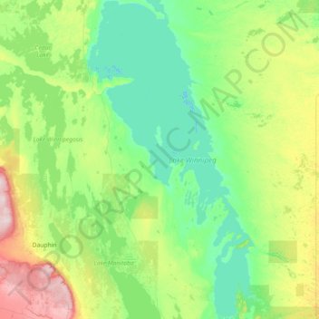
Nombre: Mapa topográfico Lake Winnipeg, altitud, relieve.
Lugar: Lake Winnipeg, Manitoba, Canada (50.35847 -99.26855 53.87945 -96.26042)
Altitud media: 275 m
Altitud mínima: 212 m
Altitud máxima: 810 m
Haz una donación
Otros mapas topográficos
Haga clic en un mapa para ver su topografía, su altitud y su relieve.
Riding Mountain National Park
The climate in the Riding Mountain region is similar to that of other regions of southwestern Manitoba. Under the Köppen classification it has a continental climate. It includes grasslands, upland boreal and eastern deciduous forest ecosystems. The park has hot summers and cold winters, with annual rainfall…
Altitud media: 488 m
Haz una donación
Haz una donación
Turtle Mountain Provincial Park
Canada > Manitoba > Municipality of Boissevain – Morton
Turtle Mountain Provincial Park is situated on the Turtle Mountain (plateau), one of a number of significant geographic features located along the Manitoba Escarpment, the Canadian portion of the Pembina Escarpment. It is located in the Southwest Manitoba Uplands Ecoregion, within the Canadian Prairies. The…
Altitud media: 662 m
Haz una donación
Riding Mountain National Park
Canada > Manitoba > Municipality of Harrison Park > Wasagaming
Riding Mountain Biosphere Reserve covers 15,000 square kilometers of land in South-western Manitoba, with the core area, Riding Mountain National Park (RMNP), covering nearly 3,000 square kilometers. It is some 300 km northwest of Winnipeg, Manitoba. The local climate is cool and moist due to a higher…
Altitud media: 623 m
Haz una donación
Haz una donación
Haz una donación
Wasagaming
Canada > Manitoba > Unorganized Division No. 17
Wasagaming has a subarctic climate (Dfc) due to its northerly location and high elevation. Winters are extremely cold and relatively dry with little chance of a mid-winter thaw. The average annual temperature is 0.7 °C (33.3 °F). Annual precipitation is 488 mm (19.2 in).
Altitud media: 630 m
Haz una donación
Haz una donación
Haz una donación
Haz una donación
Haz una donación
Haz una donación
Haz una donación
Haz una donación
Haz una donación
Haz una donación
Haz una donación
Haz una donación
Haz una donación
Haz una donación
North Thomas Lake
Canada > Manitoba > Division No. 15 > Rural Municipality of Yellowhead
Altitud media: 596 m
Haz una donación
Haz una donación
Haz una donación
Haz una donación
Elphinstone
Canada > Manitoba > Division No. 15 > Rural Municipality of Yellowhead
Altitud media: 583 m
Haz una donación