
Mapa topográfico Killaloe
Mapa interactivo
Haga clic en el mapa para ver la altitud.
Acerca de este mapa
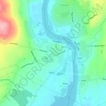
Nombre: Mapa topográfico Killaloe, altitud, relieve.
Altitud media: 58 m
Altitud mínima: 27 m
Altitud máxima: 139 m
Otros mapas topográficos
Haga clic en un mapa para ver su topografía, su altitud y su relieve.
Colmanstown
Colmanstown, Killofin ED, West Clare Municipal District, County Clare, Munster, Ireland
Altitud media: 24 m
Dehomad
Dehomad, Clondagad ED, West Clare Municipal District, County Clare, Munster, Ireland
Altitud media: 130 m
Lissycasey
Lissycasey, West Clare Municipal District, County Clare, Munster, Ireland
Altitud media: 101 m
Miltown Malbay
Miltown Malbay, Milltown Malbay ED, West Clare Municipal District, County Clare, Munster, Ireland
Altitud media: 47 m
Bunratty
Bunratty, Drumline ED, Shannon Municipal District, County Clare, Munster, Ireland
Altitud media: 9 m
Ennis
Ennis, Ennis Municipal District, County Clare, Munster, Ireland
Altitud media: 21 m
Feakle
Feakle, Killaloe Municipal District, County Clare, Munster, Ireland
Altitud media: 109 m
Affick
Affick, Newgrove ED, Killaloe Municipal District, County Clare, Munster, Ireland
Altitud media: 128 m
Mullagh
Mullagh, West Clare Municipal District, County Clare, Munster, V95 EP8Y, Ireland
Altitud media: 42 m
Killaderry (O'Brien)
Killaderry (O'Brien), Kilseily ED, Killaloe Municipal District, County Clare, Munster, Ireland
Altitud media: 72 m
Barefield
Barefield, Templemaley ED, Ennis Municipal District, County Clare, Munster, Ireland
Altitud media: 21 m
Doonbeg
Doonbeg, West Clare Municipal District, County Clare, Munster, Ireland
Altitud media: 11 m
Kiltumper
Kiltumper, Glenmore ED, West Clare Municipal District, County Clare, Munster, Ireland
Altitud media: 91 m
Doonaha West
Doonaha West, Moyarta Electoral Division, West Clare Municipal District, County Clare, Munster, Ireland
Altitud media: 23 m
Slieve Elva
Slieve Elva, West Clare Municipal District, County Clare, Munster, Ireland
Altitud media: 256 m
Kilshanny
Kilshanny, Kilshanny ED, West Clare Municipal District, County Clare, Munster, V95 T85K, Ireland
Altitud media: 52 m
Ennis
Ireland > County Clare > Ennis
Ennis, Ennis Municipal District, County Clare, Munster, V95NVF1, Ireland
Altitud media: 20 m
Leadmore East
Leadmore East, Kilrush Rural ED, West Clare Municipal District, County Clare, Munster, V15 PC56, Ireland
Altitud media: 21 m
Cliffs of Moher
Cliffs of Moher, Ballysteen ED, West Clare Municipal District, County Clare, Munster, Ireland
Altitud media: 55 m
Kilmihil
Kilmihil, Kilmihil ED, West Clare Municipal District, County Clare, Munster, Ireland
Altitud media: 67 m
Ennistimon
Ennistimon, Ennistimon ED, West Clare Municipal District, County Clare, Munster, Ireland
Altitud media: 54 m
Errina Canal
Errina Canal, Cappavilla ED, Shannon Municipal District, County Clare, Munster, V94 2N96, Ireland
Altitud media: 11 m
Doonass
Doonass, Kiltenanlea ED, Shannon Municipal District, County Clare, Munster, Ireland
Altitud media: 28 m
Ballyea North
Ballyea North, Ballyea ED, West Clare Municipal District, County Clare, Munster, Ireland
Altitud media: 70 m
Poulbaun
Poulbaun, Corrofin ED, West Clare Municipal District, County Clare, Munster, Ireland
Altitud media: 35 m
Corrifin Superintendent Registrars District
Corrifin Superintendent Registrars District, County Clare, Munster, H91 R9FX, Ireland
Altitud media: 71 m
Mountshannon
Mountshannon, Mountshannon ED, Killaloe Municipal District, County Clare, Munster, Ireland
Altitud media: 56 m
Lough Bunny
Lough Bunny, Boston ED, West Clare Municipal District, County Clare, Munster, Ireland
Altitud media: 23 m
Fitz's Cross
Ireland > County Clare > Doolin
Fitz's Cross, Doolin, Killilagh ED, West Clare Municipal District, County Clare, Munster, V95 DE2X, Ireland
Altitud media: 53 m
Ennis Municipal District
Ennis Municipal District, County Clare, Munster, Ireland
Altitud media: 39 m
Kilkishen
Kilkishen, Killaloe Municipal District, County Clare, Munster, Ireland
Altitud media: 31 m
Meelick
Ireland > County Clare > Meelick
Meelick, Shannon Municipal District, County Clare, Munster, V94 EC5T, Ireland
Altitud media: 46 m
Crusheen
Ireland > County Clare > Crusheen
Crusheen, Killaloe Municipal District, County Clare, Munster, V95 A5F2, Ireland
Altitud media: 36 m
Rosneillan
Rosneillan, Killuran ED, Killaloe Municipal District, County Clare, Munster, Ireland
Altitud media: 39 m
Knock
Knock, Kilcloher ED, West Clare Municipal District, County Clare, Munster, Ireland
Altitud media: 61 m
Knockaunroe
Knockaunroe, Dysert ED, West Clare Municipal District, County Clare, Munster, Ireland
Altitud media: 92 m
Bridgetown
Ireland > County Clare > Bridgetown
Bridgetown, Killaloe Municipal District, County Clare, Munster, Ireland
Altitud media: 68 m
Caher (Power)
Caher (Power), Derrynagittagh ED, Killaloe Municipal District, County Clare, Munster, Ireland
Altitud media: 68 m
Bealaha
Bealaha, Knocknagore ED, West Clare Municipal District, County Clare, Munster, V15 DH28, Ireland
Altitud media: 17 m
Knockbeha
Knockbeha, Corlea ED, Killaloe Municipal District, County Clare, Munster, Ireland
Altitud media: 121 m
Aglish
Aglish, Glenroe ED, West Clare Municipal District, County Clare, Munster, Ireland
Altitud media: 27 m
Foohagh Point
Foohagh Point, Kilfearagh ED, West Clare Municipal District, County Clare, Munster, Ireland
Altitud media: 24 m
Ennistimon
Ireland > County Clare > Ennistimon
Ennistimon, West Clare Municipal District, County Clare, Munster, Ireland
Altitud media: 61 m
Kilchreest
Kilchreest, West Clare Municipal District, County Clare, Munster, Ireland
Altitud media: 35 m
Knocknagarhoon
Knocknagarhoon, Tullig ED, West Clare Municipal District, County Clare, Munster, Ireland
Altitud media: 45 m
Breaffy South
Breaffy South, Milltown Malbay ED, West Clare Municipal District, County Clare, Munster, Ireland
Altitud media: 13 m
Cloghaunsavaun
Cloghaunsavaun, Kilballyowen ED, West Clare Municipal District, County Clare, Munster, Ireland
Altitud media: 15 m
Caheraphuca
Caheraphuca, Crusheen ED, Killaloe Municipal District, County Clare, Munster, Ireland
Altitud media: 31 m
Doolin
Doolin, Killilagh ED, West Clare Municipal District, County Clare, Munster, Ireland
Altitud media: 38 m