
Mapa topográfico Ostrand der Arendseer Hochfläche
Mapa interactivo
Haga clic en el mapa para ver la altitud.
Acerca de este mapa
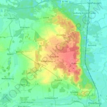
Nombre: Mapa topográfico Ostrand der Arendseer Hochfläche, altitud, relieve.
Altitud media: 35 m
Altitud mínima: 18 m
Altitud máxima: 74 m
Otros mapas topográficos
Haga clic en un mapa para ver su topografía, su altitud y su relieve.
Krevese
Deutschland > Sachsen-Anhalt > Osterburg (Altmark) > Krevese
Krevese, Osterburg (Altmark), Stendal, Sachsen-Anhalt, Deutschland
Altitud media: 47 m
Dequede
Deutschland > Sachsen-Anhalt > Osterburg (Altmark) > Krevese
Dequede, Krevese, Osterburg (Altmark), Stendal, Sachsen-Anhalt, Deutschland
Altitud media: 59 m