
Mapa topográfico Al Ain
Mapa interactivo
Haga clic en el mapa para ver la altitud.
Acerca de este mapa
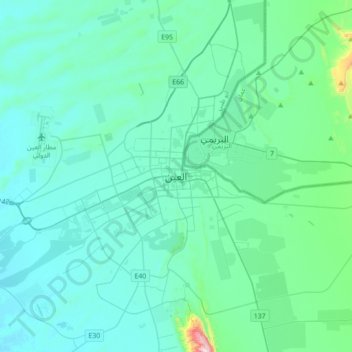
Nombre: Mapa topográfico Al Ain, altitud, relieve.
Altitud media: 294 m
Altitud mínima: 204 m
Altitud máxima: 1.056 m
Al Ain is located approximately 160 kilometres (99 mi) east of the capital Abu Dhabi, and about 120 kilometres (75 mi) south of Dubai. The eastern region covers an area of approximately 13,100 km2 (5,100 sq mi). Oman lies to the east, Dubai and Sharjah to the north, Abu Dhabi to the west and the Empty Quarter desert and Saudi Arabia to the south. The topography of Al-Ain is unique and varies as one travels to the east. The ecologically important Jebel Hafeet ("Mount Hafeet"), an outlier of the main Hajar range, is considered one of the monuments of Al-Ain, lying just to the south of the city. Rising to 1,100–1,400 metres (0.68–0.87 miles) in elevation, Jabal Hafeet is one of the highest mountains in the country, and has a number of ridges which stretch to the inner part of the city, two of which are Jabal An-Naqfah (which touches Al-Ain Oasis), and the Western ridge. Sand dunes of varying texture that are tinged red with iron oxide lie to the north and east of Al-Ain.