
Mapa topográfico Crimean Peninsula
Mapa interactivo
Haga clic en el mapa para ver la altitud.
Acerca de este mapa
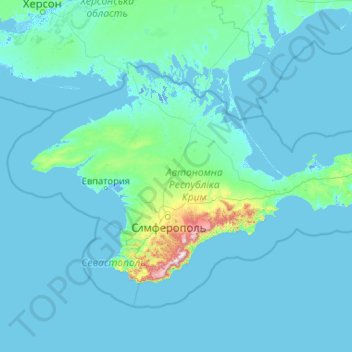
Nombre: Mapa topográfico Crimean Peninsula, altitud, relieve.
Altitud media: 35 m
Altitud mínima: -5 m
Altitud máxima: 1.514 m
The main range of these mountains rises with extraordinary abruptness from the deep floor of the Black Sea to an altitude of 600–1,545 metres (1,969–5,069 ft), beginning at the southwest point of the peninsula, called Cape Fiolent. Some Greek myths state that this cape was supposedly crowned with the temple of Artemis where Iphigeneia officiated as priestess. Uchan-su, on the south slope of the mountains, is the highest waterfall in Crimea.
Otros mapas topográficos
Haga clic en un mapa para ver su topografía, su altitud y su relieve.
Sevastopol
Sevastopol, Southern Federal District, 99001, Russia
Altitud media: 58 m