
Mapa topográfico Watertown
Mapa interactivo
Haga clic en el mapa para ver la altitud.
Watertown
According to the United States Census Bureau, the city has a total area of 25.04 square miles (64.85 km2), of which 17.45 square miles (45.20 km2) is land and 7.59 square miles (19.66 km2) is water. Watertown sits on the Big Sioux River and two major lakes, Pelican Lake and Lake Kampeska. Most of Watertown also sits upon a short plateau. The elevation at Watertown Regional Airport is 1,745 feet.
Acerca de este mapa
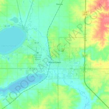
Nombre: Mapa topográfico Watertown, altitud, relieve.
Altitud media: 538 m
Altitud mínima: 518 m
Altitud máxima: 599 m
Otros mapas topográficos
Haga clic en un mapa para ver su topografía, su altitud y su relieve.
Watertown
United States > South Dakota > Codington County > Watertown
According to the United States Census Bureau, the city has a total area of 25.04 square miles (64.85 km2), of which 17.45 square miles (45.20 km2) is land and 7.59 square miles (19.66 km2) is water. Watertown sits on the Big Sioux River and two major lakes, Pelican Lake and Lake Kampeska. Most of Watertown…
Altitud media: 550 m