
Mapa topográfico Berlin
Mapa interactivo
Haga clic en el mapa para ver la altitud.
Acerca de este mapa
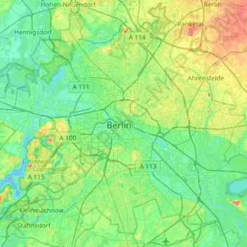
Nombre: Mapa topográfico Berlin, altitud, relieve.
Lugar: Berlin, 10117, Germany (52.35704 13.22886 52.67704 13.54886)
Altitud media: 47 m
Altitud mínima: 26 m
Altitud máxima: 113 m
Berlin straddles the banks of the River Spree, which flows into the River Havel (a tributary of the River Elbe) in the western borough of Spandau. Among the city's main topographical features are the many lakes in the western and southeastern boroughs formed by the Spree, Havel, and Dahme rivers (the largest of which is Lake Müggelsee). Due to its location in the European Plain, Berlin is influenced by a temperate seasonal climate. About one-third of the city's area is composed of forests, parks, gardens, rivers, canals and lakes. The city lies in the Central German dialect area, the Berlin dialect being a variant of the Lusatian-New Marchian dialects.
Otros mapas topográficos
Haga clic en un mapa para ver su topografía, su altitud y su relieve.
Flughafensee
Flughafensee, Tegel, Reinickendorf, Berlin, 13405, Germany
Altitud media: 35 m
Schöneberg
Schöneberg, Tempelhof-Schöneberg, Berlin, Germany
Altitud media: 46 m