
Mapa topográfico Amman
Mapa interactivo
Haga clic en el mapa para ver la altitud.
Acerca de este mapa
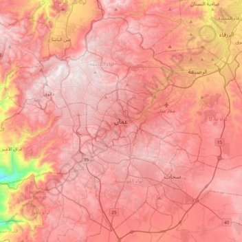
Nombre: Mapa topográfico Amman, altitud, relieve.
Altitud media: 800 m
Altitud mínima: 91 m
Altitud máxima: 1.097 m
Amman is situated on the East Bank Plateau, an upland characterized by three major wadis which run through it. Originally, the city had been built on seven hills. Amman's terrain is typified by its mountains. The most important areas in the city are named after the hills or mountains they lie on. The area's elevation ranges from 1,000 to 1,100 m (3,300 to 3,600 ft). Al-Salt and al-Zarqa are located to the northwest and northeast, respectively, Madaba is located to the west, and al-Karak and Ma'an are to Amman's southwest and southeast, respectively. One of the only remaining springs in Amman now supplies the Zarqa River with water.
Otros mapas topográficos
Haga clic en un mapa para ver su topografía, su altitud y su relieve.
Abdoun
Jordan > Amman > Amman Sub-District > Amman
Abdoun, منطقة زهران, Amman, Amman Sub-District, Amman Qasabah District, Amman, 11181, Jordan
Altitud media: 896 m