
Mapa topográfico Statesboro
Mapa interactivo
Haga clic en el mapa para ver la altitud.
Acerca de este mapa
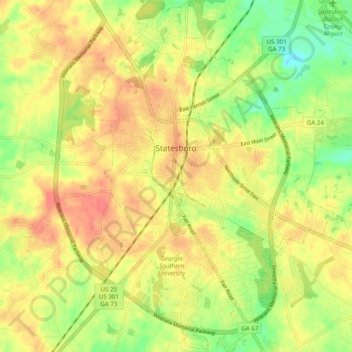
Nombre: Mapa topográfico Statesboro, altitud, relieve.
Lugar: Statesboro, Bulloch County, Georgia, United States (32.40111 -81.80676 32.48358 -81.73152)
Altitud media: 66 m
Altitud mínima: 37 m
Altitud máxima: 86 m
According to the United States Census Bureau, the city has a total area of 13.9 square miles (35.9 km2), of which 13.5 square miles (35.0 km2) is land and 0.35 square miles (0.9 km2), or 2.60%, is water. The city is in the coastal plain region, or Low Country, of Georgia, so it is mainly flat with a few small hills. With an elevation of 250 feet (76 m), the downtown area is one of the highest places in Bulloch County. Pine, oak, magnolia, dogwood, palm, sweetgum, and a variety of other trees can be found in the area.
Otros mapas topográficos
Haga clic en un mapa para ver su topografía, su altitud y su relieve.
Portal
United States > Georgia > Bulloch County
Portal, Bulloch County, Georgia, United States
Altitud media: 85 m
Lakeview Estates
United States > Georgia > Bulloch County > Statesboro
Lakeview Estates, Statesboro, Bulloch County, Georgia, 30459, United States
Altitud media: 65 m
Brians Chase
United States > Georgia > Bulloch County > Statesboro
Brians Chase, Statesboro, Bulloch County, Georgia, 30461, United States
Altitud media: 59 m
Register
United States > Georgia > Bulloch County
Register, Bulloch County, Georgia, United States
Altitud media: 57 m
Brooklet
United States > Georgia > Bulloch County
Brooklet, Bulloch County, Georgia, United States
Altitud media: 49 m