
Mapa topográfico Leavenworth
Mapa interactivo
Haga clic en el mapa para ver la altitud.
Acerca de este mapa
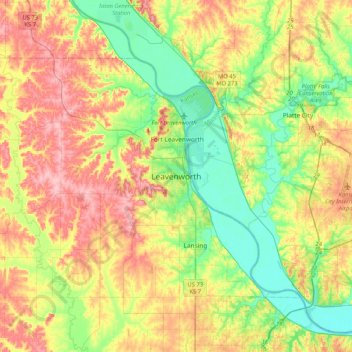
Nombre: Mapa topográfico Leavenworth, altitud, relieve.
Altitud media: 277 m
Altitud mínima: 223 m
Altitud máxima: 347 m
Leavenworth is located at 39°18′40″N 94°55′21″W / 39.31111°N 94.92250°W / 39.31111; -94.92250 (39.3111112, −94.9224637) at an elevation of 840 feet (256 m). Located in northeastern Kansas at the junction of U.S. Route 73 and Kansas Highway 92 (K-92), Leavenworth is 25 mi (40 km) northwest of downtown Kansas City, 145 mi (233 km) south-southeast of Omaha, and 165 mi (266 km) northeast of Wichita.