
Mapa topográfico Almora
Mapa interactivo
Haga clic en el mapa para ver la altitud.
Acerca de este mapa
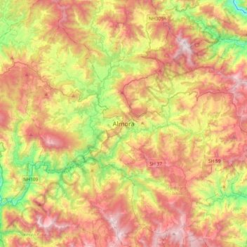
Nombre: Mapa topográfico Almora, altitud, relieve.
Lugar: Almora, Uttarakhand, 263600, India (29.44168 79.50338 29.76168 79.82338)
Altitud media: 1.557 m
Altitud mínima: 762 m
Altitud máxima: 2.383 m
Almora is located at 29°35′50″N 79°39′33″E / 29.5971°N 79.6591°E / 29.5971; 79.6591 in Almora district in Uttarakhand. Almora is situated 365 km north-east the national capital New Delhi and 415 km south-east the state capital Dehradun. It lies in the revenue Division Kumaon and is located 63 km north of Nainital, the administrative headquarters of Kumaon. It has an average elevation of 1,861 m (6,106 ft) above mean Sea Level.
Otros mapas topográficos
Haga clic en un mapa para ver su topografía, su altitud y su relieve.
Kosi River
India > Uttarakhand > Almora
Kosi River, Almora, Uttarakhand, 263600, India
Altitud media: 1.436 m
Alaknanda River
India > Uttarakhand > Almora
Alaknanda River, Almora, Uttarakhand, 263600, India
Altitud media: 1.391 m