
Mapa topográfico Kodaikanal
Mapa interactivo
Haga clic en el mapa para ver la altitud.
Acerca de este mapa
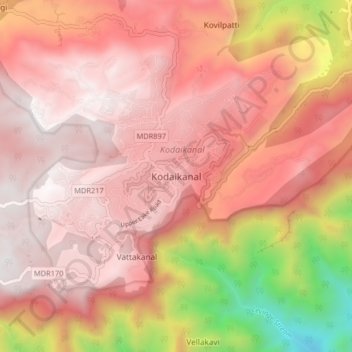
Nombre: Mapa topográfico Kodaikanal, altitud, relieve.
Lugar: Kodaikanal, Dindigul District, Tamil Nadu, 624100, India (10.19512 77.45383 10.27512 77.53383)
Altitud media: 1.763 m
Altitud mínima: 506 m
Altitud máxima: 2.337 m
Kodaikanal has a monsoon-influenced subtropical highland climate (Cfb, according to the Köppen climate classification, with a Cwb tendency). The temperatures are cool throughout the year due to the high elevation of the city.
Otros mapas topográficos
Haga clic en un mapa para ver su topografía, su altitud y su relieve.
Silver Cascade Falls
India > Tamil Nadu > Kodaikanal > Kodaikanal
Silver Cascade Falls, Kodaikanal, Dindigul District, Tamil Nadu, 624100, India
Altitud media: 1.890 m
Kodaikanal Solar Observatory
India > Tamil Nadu > Kodaikanal > Kodaikanal
Kodaikanal Solar Observatory, Lake Bridge - Observatory Road, Kodaikanal, Dindigul District, Tamil Nadu, 624100, India
Altitud media: 2.238 m