
Mapa topográfico Cockermouth
Mapa interactivo
Haga clic en el mapa para ver la altitud.
Cockermouth
Cockermouth has a temperate climate that is influenced by the Irish Sea and its low-lying elevation. Cockermouth receives slightly below average rainfall compared with the UK average. Temperatures are also round about average compared with other parts of the UK. The nearest weather station for which online records are available is Aspatria, about 7 miles (11 kilometres) north-northeast of the town centre.
Acerca de este mapa
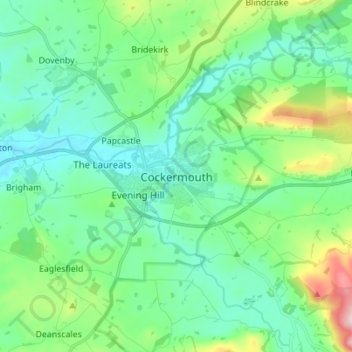
Nombre: Mapa topográfico Cockermouth, altitud, relieve.
Altitud media: 105 m
Altitud mínima: 30 m
Altitud máxima: 361 m