
Mapa topográfico Rajasthan
Mapa interactivo
Haga clic en el mapa para ver la altitud.
Acerca de este mapa
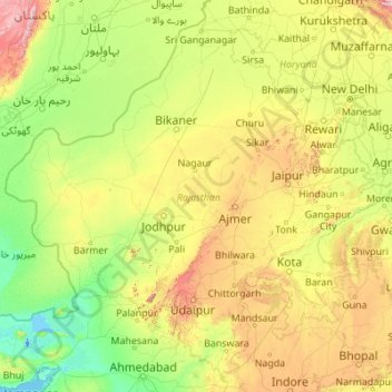
Nombre: Mapa topográfico Rajasthan, altitud, relieve.
Lugar: Rajasthan, India (23.05866 69.48444 30.19825 78.27201)
Altitud media: 254 m
Altitud mínima: -5 m
Altitud máxima: 2.299 m
The Aravalli Range runs across the state from the southwest peak Guru Shikhar (Mount Abu), which is 1,722 metres (5,650 ft) in height, to Khetri in the northeast. This range divides the state into 60% in the northwest of the range and 40% in the southeast. The northwest tract is sandy and unproductive with little water but improves gradually from desert land in the far west and northwest to comparatively fertile and habitable land towards the east. The area includes the Thar Desert. The south-eastern area, higher in elevation (100 to 350 m above sea level) and more fertile, has a very diversified topography. In the south lies the hilly tract of Mewar. In the southeast, a large area within the districts of Kota and Bundi forms a tableland. To the northeast of these districts is a rugged region (badlands) following the line of the Chambal River. Farther north the country levels out; the flat plains of the northeastern Bharatpur district are part of an alluvial basin. Merta City lies in the geographical center of Rajasthan.
Otros mapas topográficos
Haga clic en un mapa para ver su topografía, su altitud y su relieve.
Hyderabad
India > Telangana > Bahadurpura mandal
Hyderabad, Bahadurpura mandal, Hyderabad District, Telangana, India
Altitud media: 549 m
gehunlad
India > Uttarakhand > Chaubatta Khal
gehunlad, Chaubatta Khal, Pauri Garhwal District, Uttarakhand, India
Altitud media: 1.625 m
Mangaluru
India > Karnataka > Mangaluru taluk
Mangaluru, Mangaluru taluk, Dakshina Kannada District, Karnataka, 575001, India
Altitud media: 25 m
Thanjavur
India > Tamil Nadu > Thanjavur
Thanjavur, Thanjavur District, Tamil Nadu, 613001, India
Altitud media: 49 m
Anaikatti
India > Tamil Nadu > Coimbatore North
Anaikatti, Mannarkad, Palakkad District, Kerala, 678741, India
Altitud media: 623 m
Delhi
India > Delhi > Kotwali Tehsil
Delhi, Kotwali Tehsil, Central Delhi, Delhi, 110006, India
Altitud media: 216 m
Pune
India > Maharashtra > Pune City > Pune
Pune, Pune City, Pune District, Maharashtra, 411001, India
Altitud media: 641 m
Surat
India > Gujarat > Katargam Taluka > Surat
Surat, Katargam Taluka, Surat, Gujarat, 395001, India
Altitud media: 11 m
Bengaluru
India > Karnataka > Bangalore North
Bengaluru, Bangalore North, Bengaluru Urban District, Karnataka, India
Altitud media: 881 m
Shakarpur
India > Delhi > Gandhi Nagar Tehsil
Shakarpur, Gandhi Nagar Tehsil, East Delhi District, Delhi, India
Altitud media: 206 m
Clappana
India > Kerala > Karunagappally
Clappana, Karunagappally, Kollam District, Kerala, 690525, India
Altitud media: 5 m
Dahej
India > Gujarat > Vagra Taluka
Dahej, Vagra Taluka, Bharuch District, Gujarat, 393125, India
Altitud media: 6 m
Siliguri
India > West Bengal > Siliguri Subdivsion
Siliguri, Siliguri Subdivsion, Darjeeling District, West Bengal, India
Altitud media: 121 m
Warud
India > Maharashtra > Buldhana
Warud, Buldhana, Buldhana District, Maharashtra, India
Altitud media: 594 m
Naula
India > Uttarakhand > Bhanoli
Naula, Bhanoli, Almora District, Uttarakhand, India
Altitud media: 1.562 m
Rajmachi Fort
India > Maharashtra > Mawal > Udhewadi
Rajmachi Fort, Udhewadi, Mawal, Pune District, Maharashtra, India
Altitud media: 501 m
Malhargad Fort
India > Maharashtra > Purandhar
Malhargad Fort, Malhargad Walking Path, Purandhar, Pune District, Maharashtra, India
Altitud media: 822 m
Visapur Fort
India > Maharashtra > Mawal > Patan
Visapur Fort, Bhatrishi peak, Patan, Mawal, Pune District, Maharashtra, 410401, India
Altitud media: 818 m
Dadholi
India > Uttarakhand > Dwarahat
Dadholi, Dwarahat, Almora District, Uttarakhand, 263654, India
Altitud media: 1.449 m
Sinhagad Vikas Udyan
India > Maharashtra > Pune
Sinhagad Vikas Udyan, Vadgaon Budruk, Pune, Pune District, Maharashtra, 411051, India
Altitud media: 580 m
Asundi
India > Karnataka > Bellary taluk
Asundi, Bellary taluk, Ballari District, Karnataka, India
Altitud media: 419 m
Mandi
India > Himachal Pradesh > Mandi
Mandi, Mandi District, Himachal Pradesh, 175001, India
Altitud media: 1.273 m
Musi River
Musi River, Hyderabad, Uppal mandal, Medchal–Malkajgiri, Telangana, 5000036, India
Altitud media: 490 m
Panvel
India > Maharashtra > Panvel > Panvel
Panvel, Raigad, Maharashtra, 410206, India
Altitud media: 75 m
saraikhet
India > Uttarakhand > Dhoomakot
saraikhet, Dhoomakot, Pauri Garhwal District, Uttarakhand, India
Altitud media: 1.861 m
Dudori
India > Uttarakhand > Syalde > Kaljipa
Dudori, Kaljipa, Syalde, Almora District, Uttarakhand, 263665, India
Altitud media: 1.564 m
Vairavanpatti
India > Tamil Nadu > Thiruppathur
Vairavanpatti, Thiruppathur, Sivagangai District, Tamil Nadu, 630207, India
Altitud media: 103 m
Vadodara
India > Gujarat > Vadodara Taluka
Vadodara, Vadodara Taluka, Vadodara District, Gujarat, 390001, India
Altitud media: 36 m
Tung Fort
India > Maharashtra > Mawal
Tung Fort, Mawal, Pune District, Maharashtra, India
Altitud media: 733 m
Torna Fort
India > Maharashtra > Velhe
Torna Fort, Rajgad - Torna trail, Velhe, Pune District, Maharashtra, 412212, India
Altitud media: 1.013 m
Arani
India > Tamil Nadu > Arani
Arani, Tiruvannamalai District, Tamil Nadu, 632300, India
Altitud media: 143 m
Jorasi
India > Madhya Pradesh > Dabra Tahsil
Jorasi, Dabra Tahsil, Gwalior District, Madhya Pradesh, India
Altitud media: 256 m