
Mapa topográfico Maharashtra
Mapa interactivo
Haga clic en el mapa para ver la altitud.
Acerca de este mapa
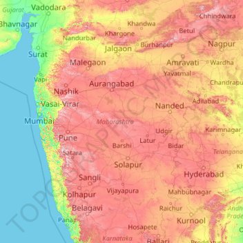
Nombre: Mapa topográfico Maharashtra, altitud, relieve.
Lugar: Maharashtra, India (15.60636 72.65261 22.03025 80.89778)
Altitud media: 346 m
Altitud mínima: -1 m
Altitud máxima: 1.418 m
Maharashtra with a total area of 307,713 km2 (118,809 sq mi), is the third-largest state by area in terms of land area and constitutes 9.36 per cent of India's total geographical area. The State lies between 15°35' N to 22°02' N latitude and 72°36' E to 80°54' E longitude. It occupies the western and central part of the country and has a coastline stretching 840 kilometres along the Arabian Sea. The dominant physical feature of the state is its plateau character, which is separated from the Konkan coastline by the mountain range of the Western Ghats, which runs parallel to the coast from north to south.The Western Ghats, also known as the Sahyadri Range, has an average elevation of 1,200 metres (4,000 ft); its slopes gently descending towards the east and southeast. The Western Ghats (or the Sahyadri Mountain range) provide a physical barrier to the state on the west, while the Satpura Hills along the north and Bhamragad-Chiroli-Gaikhuri ranges on the east serve as its natural borders. This state's expansion from North to South is 700 km and East to West is 800 km. To the west of these hills lie the Konkan coastal plains, 50–80 kilometres in width. To the east of the Ghats lies the flat Deccan Plateau. The main rivers of the state are the Krishna, and its tributary, Bhima, the Godavari, and its main tributaries, Manjara, and Wardha-Wainganga and the Tapi, and its tributary Purna. Maharashtra is divided into five geographic regions. Konkan is the western coastal region, between the Western Ghats and the sea. Khandesh is the north region lying in the valley of the Tapti, Purna river. Nashik, Malegaon Jalgaon, Dhule and Bhusawal are the major cities of this region. Desh is in the center of the state. Marathwada, which was a part of the princely state of Hyderabad until 1956, is located in the southeastern part of the state. Aurangabad and Nanded are the main cities of the region. Vidarbha is the easternmost region of the state, formerly part of the Central Provinces and Berar.
Otros mapas topográficos
Haga clic en un mapa para ver su topografía, su altitud y su relieve.
Vairavanpatti
India > Tamil Nadu > Thiruppathur
Vairavanpatti, Thiruppathur, Sivagangai District, Tamil Nadu, 630207, India
Altitud media: 103 m
Dehradun
India > Uttarakhand > Dehradun
Dehradun, Dehradun District, Uttarakhand, 248001, India
Altitud media: 904 m
Hyderabad
India > Telangana > Bahadurpura mandal
Hyderabad, Bahadurpura mandal, Hyderabad District, Telangana, India
Altitud media: 549 m
Sirpur
India > Chhattisgarh > Mahasamund Tahsil
Sirpur, Mahasamund Tahsil, Mahasamund District, Chhattisgarh, India
Altitud media: 255 m
Bengaluru
India > Karnataka > Bangalore North
Bengaluru, Bangalore North, Bengaluru Urban, Karnataka, India
Altitud media: 886 m
Asundi
India > Karnataka > Bellary taluk
Asundi, Bellary taluk, Ballari District, Karnataka, India
Altitud media: 419 m
Yalpi
India > Karnataka > Bellary taluk
Yalpi, Bellary taluk, Ballari District, Karnataka, India
Altitud media: 419 m
Konchigeri
India > Karnataka > Siruguppa taluku
Konchigeri, Siruguppa taluku, Ballari District, Karnataka, 583120, India
Altitud media: 421 m
Aspur
India > Rajasthan > Aspur Tehsil
Aspur, Aspur Tehsil, Dungarpur District, Rajasthan, 314021, India
Altitud media: 223 m
Sabla
India > Rajasthan > Sabla Tehsil
Sabla, Sabla Tehsil, Dungarpur District, Rajasthan, 314022, India
Altitud media: 177 m
Bhemai
India > Rajasthan > Galiakot Tehsil
Bhemai, Galiakot Tehsil, Dungarpur District, Rajasthan, India
Altitud media: 187 m
Gowari
India > Rajasthan > Sagwara Tehsil
Gowari, Sagwara Tehsil, Dungarpur District, Rajasthan, India
Altitud media: 178 m
Kariyana
India > Rajasthan > Sagwara Tehsil
Kariyana, Sagwara Tehsil, Dungarpur District, Rajasthan, 314032, India
Altitud media: 167 m
Sagwara
India > Rajasthan > Sagwara Tehsil
Sagwara, Sagwara Tehsil, Dungarpur District, Rajasthan, 314025, India
Altitud media: 177 m
Jhonthri
India > Rajasthan > Jhonthtri Tehsil
Jhonthri, Jhonthtri Tehsil, Dungarpur District, Rajasthan, 314404, India
Altitud media: 284 m
Mandi
India > Himachal Pradesh > Mandi
Mandi, Mandi District, Himachal Pradesh, 175001, India
Altitud media: 1.273 m
Sirpur
India > Madhya Pradesh > Khalwa Tahsil
Sirpur, Khalwa Tahsil, Khandwa District, Madhya Pradesh, India
Altitud media: 313 m
Anaikatti
India > Tamil Nadu > Coimbatore North
Anaikatti, Mannarkad, Palakkad District, Kerala, 678741, India
Altitud media: 623 m
Musi River
Musi River, Hyderabad, Uppal mandal, Medchal–Malkajgiri, Telangana, 5000036, India
Altitud media: 490 m
Mangaluru
India > Karnataka > Mangaluru taluk
Mangaluru, Mangaluru taluk, Dakshina Kannada District, Karnataka, 575001, India
Altitud media: 25 m
Navi Mumbai
India > Maharashtra > Thane > Navi Mumbai
Navi Mumbai, Mumbai Metropolitan Region, Thane, Maharashtra, 400706, India
Altitud media: 30 m
Vadodara
India > Gujarat > Vadodara Taluka
Vadodara, Vadodara Taluka, Vadodara District, Gujarat, 390001, India
Altitud media: 36 m
Surat
India > Gujarat > Katargam Taluka > Surat
Surat, Katargam Taluka, Surat, Gujarat, 395001, India
Altitud media: 11 m
Madurai
India > Tamil Nadu > Madurai
Madurai, Madurai South, Madurai district, Tamil Nadu, India
Altitud media: 138 m
Pune
India > Maharashtra > Pune City > Pune
Pune, Pune City, Pune District, Maharashtra, 411001, India
Altitud media: 641 m
Thanjavur
India > Tamil Nadu > Thanjavur
Thanjavur, Thanjavur District, Tamil Nadu, 613001, India
Altitud media: 49 m
Kampur
India > Madhya Pradesh > Raisen Tahsil
Kampur, Raisen Tahsil, Raisen District, Madhya Pradesh, India
Altitud media: 462 m
Aspur
India > Madhya Pradesh > Pichhore Tahsil > Chhatapur
Aspur, Chhatapur, Pichhore Tahsil, Shivpuri District, Madhya Pradesh, India
Altitud media: 365 m
Ganganamidde
India > Karnataka > Chikkaballapura taluk
Ganganamidde, Chikkaballapura taluk, Chikkaballapura District, Karnataka, 562101, India
Altitud media: 920 m
Borigama Chhota
India > Rajasthan > Sabla Tehsil
Borigama Chhota, Sabla Tehsil, Dungarpur District, Rajasthan, India
Altitud media: 169 m
Sabla
India > Maharashtra > Kaij
Sabla, Kaij, Beed District, Maharashtra, 431123, India
Altitud media: 730 m