
Mapa topográfico Sangamner
Mapa interactivo
Haga clic en el mapa para ver la altitud.
Acerca de este mapa
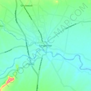
Nombre: Mapa topográfico Sangamner, altitud, relieve.
Lugar: Sangamner, Ahmednagar, Maharashtra, 422605, India (19.52634 74.17126 19.60634 74.25126)
Altitud media: 566 m
Altitud mínima: 542 m
Altitud máxima: 675 m
Sangamner is located at 19°34′N 74°13′E / 19.57°N 74.22°E / 19.57; 74.22, on the banks of the Pravara River. It has an average elevation of 549 metres (1,801 ft)from mean sea level. Sangamner is the biggest settlement on NH 50 (New NH-60) between Pune (143 km distance) and Nashik (69 km distance). It is about 230 km from financial capital of India, Mumbai. On 15 August 2014, newly constructed by-pass was opened for traffic (9.5 km) which saves about 30.0 min of commute time. In recent years, the city outskirts has been developed tremendously. Kalsubai, the highest peak in Maharashtra is 68 km from Sangamner. It is the most developed city, largest market place (bazarpeth) in district after Ahemadnagar city.
Otros mapas topográficos
Haga clic en un mapa para ver su topografía, su altitud y su relieve.
Ghulewadi
India > Maharashtra > Sangamner
Ghulewadi, Sangamner, Ahmednagar, Maharashtra, 422608, India
Altitud media: 593 m