
Mapa topográfico Mount Abu
Mapa interactivo
Haga clic en el mapa para ver la altitud.
Acerca de este mapa
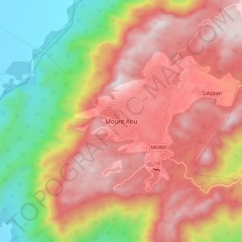
Nombre: Mapa topográfico Mount Abu, altitud, relieve.
Lugar: Mount Abu, Abu Road Tehsil, Sirohi, Rajasthan, 307500, India (24.55243 72.66819 24.63243 72.74819)
Altitud media: 914 m
Altitud mínima: 279 m
Altitud máxima: 1.422 m
Mount Abu town, the only hill station in Rajasthan, is at an elevation of 1,220 m (4,003 ft). It has been a popular retreat from the heat of Rajasthan and neighbouring Gujarat for centuries.
Otros mapas topográficos
Haga clic en un mapa para ver su topografía, su altitud y su relieve.
Nakki Lake
Nakki Lake, Path to Toad rock, Mount Abu, Abu Road Tehsil, Sirohi, Rajasthan, 307500, India
Altitud media: 1.120 m