
Mapa topográfico Uttar Pradesh
Mapa interactivo
Haga clic en el mapa para ver la altitud.
Acerca de este mapa
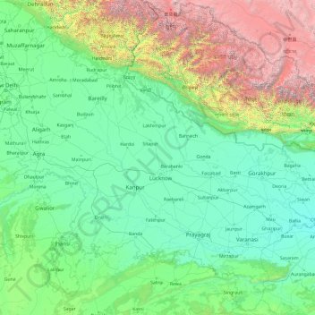
Nombre: Mapa topográfico Uttar Pradesh, altitud, relieve.
Lugar: Uttar Pradesh, India (23.87063 77.08388 30.40638 84.63451)
Altitud media: 954 m
Altitud mínima: 47 m
Altitud máxima: 7.878 m
Uttar Pradesh, with a total area of 243,290 square kilometres (93,935 sq mi), is India's fourth-largest state in terms of land area and is roughly of same size as United Kingdom. It is situated on the northern spout of India and shares an international boundary with Nepal. The Himalayas border the state on the north, but the plains that cover most of the state are distinctly different from those high mountains. The larger Gangetic Plain region is in the north; it includes the Ganges-Yamuna Doab, the Ghaghra plains, the Ganges plains and the Terai. The smaller Vindhya Range and plateau region are in the south. It is characterised by hard rock strata and a varied topography of hills, plains, valleys and plateaus. The Bhabhar tract gives place to the terai area which is covered with tall elephant grass and thick forests interspersed with marshes and swamps. The sluggish rivers of the bhabhar deepen in this area, their course running through a tangled mass of thick undergrowth. The terai runs parallel to the bhabhar in a thin strip. The entire alluvial plain is divided into three sub-regions. The first in the eastern tract consisting of 14 districts which are subject to periodical floods and droughts and have been classified as scarcity areas. These districts have the highest density of population which gives the lowest per capita land. The other two regions, the central and the western, are comparatively better with a well-developed irrigation system. They suffer from waterlogging and large-scale user tracts. In addition, the area is fairly arid. The state has more than 32 large and small rivers; of them, the Ganga, Yamuna, Saraswati, Sarayu, Betwa, and Ghaghara are larger and of religious importance in Hinduism.
Otros mapas topográficos
Haga clic en un mapa para ver su topografía, su altitud y su relieve.
Hyderabad
India > Telangana > Bahadurpura mandal
Hyderabad, Bahadurpura mandal, Hyderabad District, Telangana, India
Altitud media: 549 m
Navi Mumbai
India > Maharashtra > Thane > Navi Mumbai
Navi Mumbai, Mumbai Metropolitan Region, Thane, Maharashtra, 400706, India
Altitud media: 30 m
Udaipur
India > Rajasthan > Girwa Tehsil
Udaipur, Girwa Tehsil, Udaipur District, Rajasthan, 313001, India
Altitud media: 656 m
Thiruvananthapuram
India > Kerala > Thiruvananthapuram
Thiruvananthapuram, Thiruvananthapuram District, Kerala, 695001, India
Altitud media: 33 m
Dehradun
India > Uttarakhand > Dehradun
Dehradun, Dehradun District, Uttarakhand, 248001, India
Altitud media: 904 m
Anaikatti
India > Tamil Nadu > Coimbatore North
Anaikatti, Mannarkad, Palakkad District, Kerala, 678741, India
Altitud media: 623 m
Mangaluru
India > Karnataka > Mangaluru taluk
Mangaluru, Mangaluru taluk, Dakshina Kannada District, Karnataka, 575001, India
Altitud media: 25 m
Madurai
India > Tamil Nadu > Madurai
Madurai, Madurai South, Madurai district, Tamil Nadu, India
Altitud media: 138 m
tasila malla
India > Uttarakhand > Satpuli > Ghera
tasila malla, Ghera, Satpuli, Pauri Garhwal District, Uttarakhand, 246129, India
Altitud media: 1.141 m
Modasa
India > Gujarat > Modasa Taluka
Modasa, Modasa Taluka, Aravalli District, Gujarat, 383315, India
Altitud media: 149 m
Musi River
Musi River, Hyderabad, Uppal mandal, Medchal–Malkajgiri, Telangana, 5000036, India
Altitud media: 490 m
Delhi
India > Delhi > Kotwali Tehsil
Delhi, Kotwali Tehsil, Central Delhi, Delhi, 110006, India
Altitud media: 216 m
Bhopal
India > Madhya Pradesh > Huzur Tahsil
Bhopal, Huzur Tahsil, Bhopal District, Madhya Pradesh, 462001, India
Altitud media: 498 m
Bengaluru
India > Karnataka > Bangalore North
Bengaluru, Bangalore North, Bengaluru Urban District, Karnataka, India
Altitud media: 881 m
Thanjavur
India > Tamil Nadu > Thanjavur
Thanjavur, Thanjavur District, Tamil Nadu, 613001, India
Altitud media: 49 m
Rishikesh
India > Uttarakhand > Rishikesh
Rishikesh, Dehradun, Uttarakhand, 249201, India
Altitud media: 497 m
Pune
India > Maharashtra > Pune City > Pune
Pune, Pune City, Pune District, Maharashtra, 411001, India
Altitud media: 641 m
Karchiganuru
India > Karnataka > Siruguppa taluku
Karchiganuru, Siruguppa taluku, Ballari District, Karnataka, India
Altitud media: 366 m
Dahej
India > Gujarat > Vagra Taluka
Dahej, Vagra Taluka, Bharuch District, Gujarat, 393125, India
Altitud media: 6 m
Calvary Mount
Calvary Mount, Idukki, Idukki District, Kerala, 685512, India
Altitud media: 944 m
Kaluvoya
Kaluvoya, Sri Potti Sriramulu Nellore, Andhra Pradesh, India
Altitud media: 133 m
Chempakapara
India > Kerala > Udumbanchola > Chempakappara > Kochukamakshy
Chempakapara, Kochukamakshy, Chempakappara, Udumbanchola, Idukki District, Kerala, India
Altitud media: 811 m
Vadodara
India > Gujarat > Vadodara Taluka
Vadodara, Vadodara Taluka, Vadodara District, Gujarat, 390001, India
Altitud media: 36 m
Gunjur Palya
India > Karnataka > Bangalore East
Gunjur Palya, Bangalore East, Bengaluru Urban, Karnataka, 560087, India
Altitud media: 883 m
Katara
India > Madhya Pradesh > Kolar Tahsil
Katara, Kolar Tahsil, Bhopal District, Madhya Pradesh, India
Altitud media: 462 m
Kuvalettam
Kuvalettam, Peerumade, Idukki District, Kerala, 685503, India
Altitud media: 979 m
Gopasandra
India > Karnataka > Mulubagilu taluk
Gopasandra, Mulubagilu taluk, Kolar District, Karnataka, India
Altitud media: 804 m