
Mapa topográfico Rajkot
Mapa interactivo
Haga clic en el mapa para ver la altitud.
Rajkot
Rajkot is located at 22°18′N 70°47′E / 22.3°N 70.78°E / 22.3; 70.78. It has an average elevation of 128 metres (420 ft). The city is located on the bank of Aji River and Nyari River which remains dry except the monsoon months of July to September. The city is spread in the area of 170.00 km2.
Acerca de este mapa
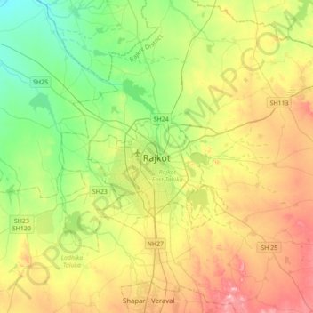
Nombre: Mapa topográfico Rajkot, altitud, relieve.
Lugar: Rajkot, Rajkot East Taluka, Rajkot, Gujarat, 360001, India (22.14533 70.64284 22.46533 70.96284)
Altitud media: 141 m
Altitud mínima: 65 m
Altitud máxima: 257 m