
Mapa topográfico Chirala
Mapa interactivo
Haga clic en el mapa para ver la altitud.
Chirala
The coordinates of the city are 15°49′29″N 80°21′08″E / 15.8246°N 80.3521°E / 15.8246; 80.3521 and is located at an altitude of 3 m (9.8 ft) from the coast of Bay of Bengal.
Acerca de este mapa
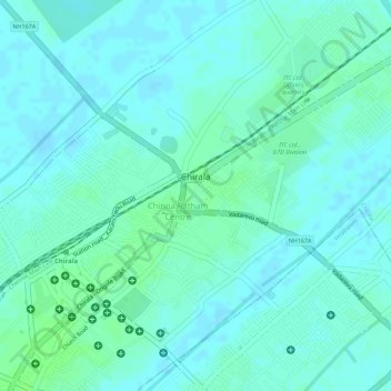
Nombre: Mapa topográfico Chirala, altitud, relieve.
Lugar: Chirala, Bapatla District, Andhra Pradesh, 523155, India (15.82356 80.35840 15.84604 80.37961)
Altitud media: 6 m
Altitud mínima: 2 m
Altitud máxima: 11 m
Otros mapas topográficos
Haga clic en un mapa para ver su topografía, su altitud y su relieve.