
Mapa topográfico Nashik
Mapa interactivo
Haga clic en el mapa para ver la altitud.
Acerca de este mapa
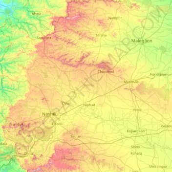
Nombre: Mapa topográfico Nashik, altitud, relieve.
Lugar: Nashik, Maharashtra, India (19.51667 73.38333 20.91667 74.78333)
Altitud media: 555 m
Altitud mínima: 72 m
Altitud máxima: 1.562 m
Otros mapas topográficos
Haga clic en un mapa para ver su topografía, su altitud y su relieve.
Mumbai
India > Maharashtra > Mumbai
Mumbai is on a narrow peninsula on the southwest of Salsette Island, which lies between the Arabian Sea to the west, Thane Creek to the east and Vasai Creek to the north. Mumbai's suburban district occupies most of the island. Navi Mumbai is east of Thane Creek and Thane is north of Vasai Creek. Mumbai…
Altitud media: 18 m
Pune
Pune lies on the western margin of the Deccan plateau, at an altitude of 560 m (1,840 ft) above sea level. It is on the leeward side of the Sahyadri mountain range, which forms a barrier from the Arabian Sea. It is a hilly city, with Vetal Hill rising to 800 m (2,600 ft) above sea level. The Sinhagad fort is…
Altitud media: 616 m
Navi Mumbai
India > Maharashtra > Thane Taluka
Navi Mumbai (Marathi pronunciation: [nəʋiː mumbəiː]), is a planned city situated on the west coast of the Indian subcontinent, located in the Konkan division of Maharashtra state, on the mainland of India. Navi Mumbai is part of the Mumbai Metropolitan Region (MMR). The city is divided into two, North…
Altitud media: 22 m
Jalna District
The district occupies an area of 7,687 square kilometres (2,968 sq mi). The range of geographical latitudes and longitudes of the district is from 19.01' N to 21.03'N and from 75.04'E to 76.04'E, with gently to moderately sloping topography. The Northern part of the district is occupied by the Ajanta and…
Altitud media: 542 m
Nanded District
Nanded is bounded on the north by Yavatmal district of the Vidarbha region, with Latur on south-west, Parbhani and Hingoli districts on the west. On the eastern side lies Adilabad, Nirmal, Nizamabad and Kamareddy districts of Telangana state, and on the south lies Bidar of Karnataka state. The area presents…
Altitud media: 432 m
Khuldabad
Khuldabad is located at 20°03′N 75°11′E / 20.05°N 75.18°E / 20.05; 75.18. It enjoys a pleasant climate, moderated by its altitude (2,732 feet / 832.7 metres). The town rises about 500 feet (152.4 metres) above the surrounding plains. The world famous Ellora caves are about 4 miles from…
Altitud media: 661 m
Panhala
Panhala is located at 16°49′12″N 74°7′12″E / 16.82000°N 74.12000°E / 16.82000; 74.12000. It has an average elevation of 754 metres (2473 feet). Panhala is connected via train and bus to Kolhapur and Sangli. Kolhapur is about 21 km away while Sangli is about 60 km. Kolhapur Chhatrapati…
Altitud media: 620 m
Chikhaldara
The sole hill resort in the Vidarbha region, it is situated at an altitude of 1118 meters with highest elevation point 1188 meters and has the added dimension of being the only coffee-growing area in Maharashtra. Chikhaldara has an annual rainfall of 154cm. Temperatures vary from 39C in summer to 5C in winter.…
Altitud media: 521 m
Kolhapur District
Kolhapur experiences winter from November to February. The winter temperatures are warmer than other cities in Maharashtra such as Pune and Nashik. Lows range from 9 to 16 °C (48 to 61 °F) while highs are in the range of 24 to 32 °C (75 to 90 °F) due to its high elevation and being adjacent to the Western…
Altitud media: 464 m
Latur District
Latur district is in the Marathwada region in Maharashtra in India, located between 17°52' North to 18°50' North and 76°18' East to 79°12' East in the Deccan plateau. It has an average elevation of 631 metres (2,070 ft) above mean sea level. The entire district of Latur is on the Balaghat plateau, 540 to…
Altitud media: 590 m