Geolocalizar

Mapa topográfico Anantapuram

Haga clic en el mapa para ver la altitud.

Anantapuram

Penna, Chithravathi, Pedda Hagari, Chinna Hagari, Thadakaleru and Pandameru are the main rivers. The average elevation is about 1300 feet above the mean sea level. The annual normal rainfall of the district is 508.2 mm. Thus it secures least rainfall when compared to other parts of Andhra Pradesh.

Wikipedia (CC-BY-SA 3.0)

Acerca de este mapa

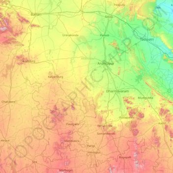
Nombre: Mapa topográfico Anantapuram, altitud, relieve.

Lugar: Anantapuram, Andhra Pradesh, India (14.21418 76.76008 15.23394 78.13747)

Altitud media: 455 m

Altitud mínima: 203 m

Altitud máxima: 1.069 m

Otros mapas topográficos

Haga clic en un mapa para ver su topografía, su altitud y su relieve.

Pasemvāripalli

India > Andhra Pradesh > Pakala > Pakala

Altitud media: 374 m

Kunchanapalli

India > Andhra Pradesh > Tadepalle

Altitud media: 20 m

Sivagiri

India > Andhra Pradesh > Pichatur

Altitud media: 80 m

Visakhapatnam

India > Andhra Pradesh > Visakhapatnam (Urban)

The city is situated between the Eastern Ghats and the Bay of Bengal. The city coordinates lies between 17.7041 N and 83.2977 E. The city's area is 682 km2. The average elevation is 45 metres. Visakhpatnam is situated in Coastal Andhra Region.

Altitud media: 35 m

Karakambadi

India > Andhra Pradesh > Renigunta

Altitud media: 143 m

Erragunta

India > Andhra Pradesh > Renigunta

Altitud media: 281 m

Satuluru

India > Andhra Pradesh > Nadendla

Altitud media: 62 m

Atmakuru ( K )

India > Andhra Pradesh > Atmakur

Altitud media: 288 m

Undavalli

India > Andhra Pradesh > Tadepalle > Amaravati

Altitud media: 30 m

Maredumilli

India > Andhra Pradesh > Maredumilli

Altitud media: 490 m

Nellore

India > Andhra Pradesh > Nellore

Nellore is located at 14°26′N 79°59′E / 14.44°N 79.98°E / 14.44; 79.98. It has an average elevation of 18 metres (59 ft).

Altitud media: 17 m

Vijayawada

India > Andhra Pradesh > Vijayawada (Urban)

Vijayawada lies on the banks of Krishna river, covered by hills and canals. and at an altitude of 11 m (36 ft) above sea level. Three canals originating from the north side of the Prakasam Barrage reservoir — Eluru, Bandar, and Ryves — flow through the city.

Altitud media: 37 m

Ongole

India > Andhra Pradesh > Ongole

Ongole is located at 15.5°N 80.05°E. It has an average elevation of 10 m (33 ft) AMSL and is situated on plains. The city is around 149 kilometres (93 mi) to the southwest of Amaravati, the state capital.

Altitud media: 15 m

Bhairavunipadu

India > Andhra Pradesh > Macherla

Altitud media: 151 m

Nimmakuru

India > Andhra Pradesh > Pamarru

Altitud media: 8 m

Bobbili

India > Andhra Pradesh > Bobbili

Bobbili is located at 18°34′00″N 83°22′00″E / 18.5667°N 83.3667°E / 18.5667; 83.3667. It has an average elevation of 103 metres (337 feet).

Altitud media: 130 m

Repalle

India > Andhra Pradesh > Repalle

Repalle is located at 16°01′N 80°31′E / 16.01°N 80.51°E / 16.01; 80.51. It has an average elevation of 7 m (23 ft) and situated 10.62 km (6.60 mi). The nearest towns are Tenali in the Guntur district, Ponnur, Bapatla in the Bapatla District and Machilipatnam in the Krishna district.

Altitud media: 5 m

Karedu

India > Andhra Pradesh > Ulavapadu

Altitud media: 5 m

Nellore

India > Andhra Pradesh > Nellore

Nellore is located at 14°26′N 79°59′E / 14.44°N 79.98°E / 14.44; 79.98. It has an average elevation of 18 metres (59 ft).

Altitud media: 17 m

Karepalli

India > Andhra Pradesh > Mandasa

Altitud media: 69 m

Mallisala

India > Andhra Pradesh > Jaggampeta

Altitud media: 120 m

Loddipalem

India > Andhra Pradesh > Gangavaram

Altitud media: 155 m

Kuchipudi

India > Andhra Pradesh > Movva

Altitud media: 8 m

Beddaguda

India > Andhra Pradesh > Araku Valley > Sunkarametta

Altitud media: 1.092 m

Kolleru

India > Andhra Pradesh > Mandavalli

Altitud media: 4 m

Indupalle

India > Andhra Pradesh > Unguturu

Altitud media: 10 m

Guntakal

India > Andhra Pradesh > Guntakal

Guntakal is located at 15°10′N 77°23′E / 15.17°N 77.38°E / 15.17; 77.38. It has an average elevation of 432 metres (1,417 ft).

Altitud media: 445 m

Ojili

India > Andhra Pradesh > Ojili

Altitud media: 28 m

Belman

India > Andhra Pradesh > Amadalavalasa

Altitud media: 19 m

Nekarikallu

India > Andhra Pradesh > Nekarikallu

Altitud media: 131 m

Sullurpeta

India > Andhra Pradesh > Sullurpeta

Sullurupeta is located about 77 km east of Tirupati, 90 km south of Nellore and about 83 km north of Chennai, Tamilnadu. It is 16 km west of the world-famous ISRO island Sriharikota, where the Indian rockets are launched. The Pulicat lake separates Sullurupeta and Sriharikota. It has an average elevation of 11…

Altitud media: 4 m

Kuppam

India > Andhra Pradesh > Kuppam

Altitud media: 690 m

Pattikonda

India > Andhra Pradesh > Pattikonda

Altitud media: 463 m

Venkannapalem

India > Andhra Pradesh > Kondapuram

Altitud media: 45 m

Narsipatnam

India > Andhra Pradesh > Narsipatnam

Narsipatnam is located at 17°40′N 82°37′E / 17.67°N 82.62°E / 17.67; 82.62. It has an average elevation of 58 metres (190 feet). This is one of the five places in India where the IST line passes

Altitud media: 88 m

B Camp

India > Andhra Pradesh > Kallur

Altitud media: 291 m

Mothadaka

India > Andhra Pradesh > Tadikonda

Altitud media: 53 m

Bangarupalyam

India > Andhra Pradesh > Amarapuram

Altitud media: 608 m

Chittoor

India > Andhra Pradesh > Chittoor

It is located between the northern latitudes of 37" and 14°8" and between the eastern longitudes 78°33" and 79°55". It is bounded on the east by Tirupati district of Andhra Pradesh, on the south by Krishnagiri District, Vellore, Tiruvallur, Thirupattur districts of Tamil Nadu, on the west by Kolar district…

Altitud media: 350 m

Dumpagadapa

India > Andhra Pradesh > Akividu

Altitud media: 4 m

Guntur

India > Andhra Pradesh > Guntur

Guntur is located at 16°17′N 80°26′E / 16.29°N 80.43°E / 16.29; 80.43. It has an average elevation of 33 metres (108 ft) and is situated on the plains. There are few hills in the surrounding suburban areas and Perecherla Reserve Forest is located in the city's north-west. Guntur lies…

Altitud media: 29 m

Kamanur

India > Andhra Pradesh > Proddatur

Altitud media: 147 m

Rekkamanu

India > Andhra Pradesh > Gandlapenta

Altitud media: 513 m

Toturu

India > Andhra Pradesh > Ichchapuram

Altitud media: 15 m

Kavanur

India > Andhra Pradesh > Nindra

Altitud media: 97 m

Ongole

India > Andhra Pradesh > Ongole

Ongole is located at 15.5°N 80.05°E. It has an average elevation of 10 m (33 ft) AMSL and is situated on plains. The city is around 149 kilometres (93 mi) to the southwest of Amaravati, the state capital.

Altitud media: 15 m

Kovur

India > Andhra Pradesh > Kovur

Altitud media: 17 m

Kothapeta

India > Andhra Pradesh > Kothapeta

Altitud media: 10 m

Dachepalli

India > Andhra Pradesh > Dachepalle

Altitud media: 101 m

Tunivalasa

India > Andhra Pradesh > Cheedikada

Altitud media: 59 m

Palutla

India > Andhra Pradesh > Dornala

Altitud media: 461 m

Palavaram

India > Andhra Pradesh > Chatrai

Altitud media: 94 m

Kovur

India > Andhra Pradesh > Kovur

Altitud media: 17 m

Penukonda

India > Andhra Pradesh > Penukonda

Altitud media: 592 m

Veeravalli

India > Andhra Pradesh > Bapulapadu

Altitud media: 19 m

Lepakshi

India > Andhra Pradesh > Lepakshi

Altitud media: 649 m

Kalyandurg

India > Andhra Pradesh > Kalyandurg

Kalyandurg is located at 14°33′00″N 77°06′00″E / 14.5500°N 77.1000°E / 14.5500; 77.1000. It has an average elevation of 591 metres (1942 ft).

Altitud media: 557 m

Halaharvi

India > Andhra Pradesh > Nandavaram

Altitud media: 353 m

Durgi

India > Andhra Pradesh > Durgi

Altitud media: 160 m

Dharmapuram

India > Andhra Pradesh > Nandavaram

Altitud media: 356 m

Gooty

India > Andhra Pradesh > Gooty

Gooty is located at 15°07′N 77°38′E / 15.12°N 77.63°E / 15.12; 77.63, at a distance of 52 km from Anantapur. It has an average elevation of 345 metres (1131 feet).

Altitud media: 364 m

Marrigunta

India > Andhra Pradesh > Renigunta

Altitud media: 112 m

Cheedivalasa

India > Andhra Pradesh > Kothavalasa

Altitud media: 73 m

Rayadurgam

India > Andhra Pradesh > Rayadurg

Altitud media: 576 m

Madakasira

India > Andhra Pradesh > Madakasira

Madakasira is located at 13°56′13″N 77°16′10″E / 13.9369°N 77.2694°E / 13.9369; 77.2694. It has an average elevation of 676 metres (2221 ft). The height of the Madakasira hill is 2936 feet from the Sea Level.Formerly Madakasira is called as SIMHAGIRI because hill from one side looks like a…

Altitud media: 684 m

Vizianagaram

India > Andhra Pradesh > Vizianagaram Mandal

Vizianagaram is located at 18°07′N 83°25′E / 18.12°N 83.42°E / 18.12; 83.42. It has an average elevation of 74 metres (242 feet). The Champavathi River flows near the city.

Altitud media: 57 m

Machilipatnam

India > Andhra Pradesh > Machilipatnam

Salabat Jung, the son of Nizam-ul-Mulk Asaf Jah I, who was indebted for his elevation to the throne to the French East India Company, granted them in return for their services the district of Kondavid or Guntur, and soon afterwards the remainder of the Circars. The Circars were captured by the British from the…

Altitud media: 4 m

Allagadda

India > Andhra Pradesh > Allagadda

Altitud media: 176 m

Mambattu

India > Andhra Pradesh > Tada

Altitud media: 12 m

Srikakulam

India > Andhra Pradesh > Srikakulam

Altitud media: 21 m

Markapur

India > Andhra Pradesh > Markapur

Altitud media: 151 m

Mambattu

India > Andhra Pradesh > Tada

Altitud media: 12 m

Gottipadia

India > Andhra Pradesh > Markapur

Altitud media: 256 m

Thippanur

India > Andhra Pradesh > Gonegandla

Altitud media: 361 m

Amalapuram

India > Andhra Pradesh > Amalapuram

Amalapuram is spread over an area of 7.20 km2 (2.78 sq mi). It is located at 16°34′43″N 82°00′22″E / 16.5787°N 82.0061°E / 16.5787; 82.0061. It has an average elevation of 2 m (6 ft 7 in). It is the largest town of Konaseema district.

Altitud media: 7 m