
Mapa topográfico Southampton
Mapa interactivo
Haga clic en el mapa para ver la altitud.
Acerca de este mapa
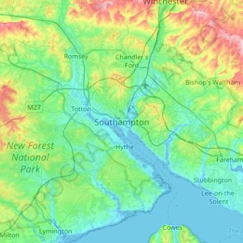
Nombre: Mapa topográfico Southampton, altitud, relieve.
Lugar: Southampton, South East, England, SO14 2BY, United Kingdom (50.74253 -1.56419 51.06253 -1.24419)
Altitud media: 38 m
Altitud mínima: -5 m
Altitud máxima: 179 m
Otros mapas topográficos
Haga clic en un mapa para ver su topografía, su altitud y su relieve.
Southampton Common
United Kingdom > England > Southampton
Southampton Common, Bassett, Southampton, England, SO15 7NN, United Kingdom
Altitud media: 34 m
West (Watts) Park
United Kingdom > England > Southampton
West (Watts) Park, Cultural Quarter, The Polygon, Southampton, England, United Kingdom
Altitud media: 10 m
East (Andrews) Park
United Kingdom > England > Southampton
East (Andrews) Park, Cultural Quarter, Bellevue, Southampton, England, SO14 0DA, United Kingdom
Altitud media: 9 m
Southampton Common
United Kingdom > England > Southampton
Southampton Common, Banister Park, Southampton, South East, England, United Kingdom
Altitud media: 28 m
Itchen
United Kingdom > England > Southampton
Itchen, Cobden Bridge, Saint Denys, Southampton, South East, England, SO17 2NR, United Kingdom
Altitud media: 22 m