
Mapa topográfico Marysville
Mapa interactivo
Haga clic en el mapa para ver la altitud.
Marysville
The city's topography varies from the low-lying downtown, located along the banks of Ebey Slough 5 feet (1.5 m) above sea level, rising to 160 feet (49 m) near Smokey Point and over 465 feet (142 m) in the eastern highlands. Marysville sits in the watershed of two major creeks, Quilceda Creek and Allen Creek, and approximately 70 minor streams that flow into Ebey Slough and Snohomish River. During the early 20th century, repeated controlled flooding and other engineering works in the Snohomish River delta contributed to the replenishment of the area's fertile silty soil for use in farming.
Acerca de este mapa
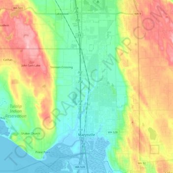
Nombre: Mapa topográfico Marysville, altitud, relieve.
Lugar: Marysville, Snohomish County, Washington, United States (48.01984 -122.28651 48.16329 -122.10961)
Altitud media: 72 m
Altitud mínima: -3 m
Altitud máxima: 201 m
Otros mapas topográficos
Haga clic en un mapa para ver su topografía, su altitud y su relieve.
Bridal Veil Falls-Lower East Cascade
United States > Washington > Snohomish County
Altitud media: 621 m
Glacier Peak
United States > Washington > Snohomish County
Despite its elevation of 10,541 feet (3,213 m), Glacier Peak is a small stratovolcano. Its relatively high summit is a consequence of its location atop a high ridge, but its volcanic portion extends only 1,600–3,200 feet (500–1,000 m) above the underlying ridge. Another Cascade Arc volcano with similar…
Altitud media: 2.656 m
Whitehorse Mountain
United States > Washington > Snohomish County
Whitehorse Mountain is a peak near the western edge of the North Cascades in Washington state. It is located just southwest of the Sauk River Valley town of Darrington, near the northern boundary of Boulder River Wilderness in Mount Baker-Snoqualmie National Forest. While not of particularly high absolute…
Altitud media: 1.430 m
Mill Creek
United States > Washington > Snohomish County > Mill Creek > Mill Creek
Altitud media: 129 m