
Mapa topográfico Stuart Island
Mapa interactivo
Haga clic en el mapa para ver la altitud.
Acerca de este mapa
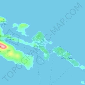
Nombre: Mapa topográfico Stuart Island, altitud, relieve.
Lugar: Stuart Island, San Juan County, Washington, United States (48.65794 -123.23741 48.68994 -123.16301)
Altitud media: 6 m
Altitud mínima: -1 m
Altitud máxima: 177 m
Otros mapas topográficos
Haga clic en un mapa para ver su topografía, su altitud y su relieve.
Vashon Island
United States > Washington > King County > Vashon
Vashon Island features a diverse topography characterized by rolling hills, lush forests, and scenic waterfronts. The island rises gently from sea level to elevations reaching around 500 feet (approximately 150 meters) at its highest point, providing sweeping views of Puget Sound and the surrounding mountains.…
Altitud media: 46 m
Snoqualmie Pass
United States > Washington > King County
Due to its elevation, Snoqualmie Pass experiences significantly lower temperatures than Seattle, and receives much more precipitation, much of it being snow. Snoqualmie Pass has a humid continental climate (Koppen: Dsb bordering Csb) with cold, very wet and snowy winters, and mild to warm, relatively dry…
Altitud media: 1.048 m
Lake Chelan
United States > Washington > Chelan County > Chelan
Lake Chelan (/ʃəˈlæn/ shə-LAN) is a narrow, 50.5 mi (81.3 km) long lake in Chelan County, north-central Washington state, U.S. It is an overdeepened lake and resembles a fjord, with an average width of 1.3 mi (2.1 km). Near its upper end, the lake surface lies more than 6,600 ft (2,000 m) below peaks less…
Altitud media: 1.358 m
Walla Walla
United States > Washington > Walla Walla County
Walla Walla County features a varied topography characterized by rolling hills, valleys, and river systems. The elevation in the area averages around 940 feet (approximately 287 meters) above sea level, with some areas rising to nearly 1,200 feet. The landscape is shaped by the Walla Walla River, which carves…
Altitud media: 297 m
Aberdeen
United States > Washington > Grays Harbor County > Aberdeen
Aberdeen is at the eastern end of Grays Harbor, near the mouth of the Chehalis River and southwest of the Olympic Mountains. Grays Harbor is notable as the northernmost ria on North America's Pacific Coast because it has remained free of glaciers throughout the Quaternary due to unfavorable topography and warm…
Altitud media: 66 m
Mount Si
United States > Washington > King County
The peak can be accessed by two trails. The Old Mount Si trail is accessed by the Little Si parking lot and the Boulder Garden Loop. It is 0.6 miles (0.97 km) shorter, 270 feet (82 m) steeper in elevation gain, and less crowded than the main trail. The Mount Si trail is accessed by the Mount Si parking lot.
Altitud media: 787 m
Grand Coulee Dam
United States > Washington > Okanogan County
After power shortages in the Northwest during the 1960s, it was determined the six remaining planned pumps be pump-generators. When energy demand is high, the pump-generators can generate electricity with water from the Banks Lake feeder canal adjacent to the dam at a higher elevation. By 1973, the…
Altitud media: 423 m
Town and Country
United States > Washington > Spokane County
The city of Spokane surrounds the CDP on three sides: the east, south and west. The city's street grid continues into Town and Country uninterrupted in the east, though it breaks down in the west along the bluff leading up to Five Mile Prairie. The bulk of the CDP lies on flat ground like the surrounding north…
Altitud media: 639 m
Hyak
United States > Washington > Kittitas County
Hyak is located two miles (3 km) east of the summit of Snoqulamie Pass at an elevation of 2,600 feet (790 m). It is 16 miles (26 km) northwest of Easton and is part of the Easton school district.
Altitud media: 907 m
Liberty Bell Mountain
United States > Washington > Chelan County
It is a well-known peak in Washington, although it lacks high prominence and elevation. It is well known for having high-quality alpine climbing, with a short approach since the completion of The Washington Pass Highway. A mixture of high-quality granite and difficult rock has made it a very popular weekend…
Altitud media: 1.834 m
Mount Skokomish Wilderness
United States > Washington > Mason County
Mount Skokomish Wilderness is located in the southeast corner of Olympic National Forest, just north of Lake Cushman. It consists of two long rocky ridges running roughly northeast to southwest. Elevations range from about 2,000 feet (609.6 m) to 6,434 feet (1,961.1 m) at the peak of Mount Skokomish on the…
Altitud media: 1.058 m
Colfax
United States > Washington > Whitman County
Colfax is located in southeastern Washington at 46°53′3″N 117°21′49″W / 46.88417°N 117.36361°W / 46.88417; -117.36361 (46.884033, -117.363668), at an elevation of 1,962 feet (598 m). The nearest cities are Spokane, Pullman, Moscow, and Lewiston/Clarkston. The area is geologically…
Altitud media: 685 m