
Mapa topográfico Mallerstang
Mapa interactivo
Haga clic en el mapa para ver la altitud.
Acerca de este mapa
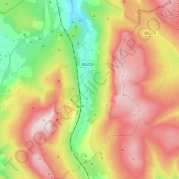
Nombre: Mapa topográfico Mallerstang, altitud, relieve.
Lugar: Mallerstang, Westmorland and Furness, England, United Kingdom (54.35475 -2.38431 54.44399 -2.29172)
Altitud media: 463 m
Altitud mínima: 213 m
Altitud máxima: 711 m
Otros mapas topográficos
Haga clic en un mapa para ver su topografía, su altitud y su relieve.
Black Fell
United Kingdom > England > Westmorland and Furness > Hawkshead
Black Fell is the high point in the hilly area bounded by Windermere, Langdale and Coniston. It occupies an area of around one mile by two, clad mainly in fell grass with many small outcrops of rock. Despite its modest altitude Alfred Wainwright accorded Black Fell a chapter in his Pictorial Guide to the…
Altitud media: 170 m
Wood Broughton
United Kingdom > England > Westmorland and Furness > Field Broughton
Altitud media: 98 m
Arnison Crag
United Kingdom > England > Westmorland and Furness > Patterdale
Although properly a northeastern ridge of Birks and having little topographical prominence, Arnison Crag was classed as a separate fell by Alfred Wainwright in his Pictorial Guide to the Lakeland Fells. That convention is followed here. In support of his decision he referred to it as ‘a low hill with a…
Altitud media: 287 m
Old Man of Coniston
United Kingdom > England > Westmorland and Furness > Coniston
The first section rising steeply from Coniston is a metalled road, maintained partly to provide access to the quarry. This leads to a car park at an altitude of 740 ft (230 m), a popular starting point for climbs. Beyond here motor vehicles are prohibited, but the track continues to its summit at 2,000 ft (610…
Altitud media: 501 m
Stony Cove Pike
United Kingdom > England > Westmorland and Furness > Patterdale
Stony Cove Pike (alternatively known as Caudale Moor /kʊərdeɪl mʊər/ or John Bell's Banner) is a fell in the Far Eastern part of the English Lake District. It stands on the other side of the Kirkstone Pass from Red Screes, and is on the end of a ridge coming down from High Street. It is separated from its…
Altitud media: 541 m
Little Langdale
United Kingdom > England > Westmorland and Furness
Little Langdale Tarn is a natural tarn within a marshy area of the valley. The area around the tarn is managed by the National Trust and has no public access. It is typical Southern Cumbrian meso-oligotrophic tarn, whilst not at a particularly high altitude itself it has a mean catchment altitude of 520 metres…
Altitud media: 183 m
Wharton Tarn
United Kingdom > England > Westmorland and Furness > Hawkshead > Hawkshead Hill
Altitud media: 173 m
Brothers Water
United Kingdom > England > Westmorland and Furness > Patterdale > Hartsop
Altitud media: 298 m
Newton Tarn
United Kingdom > England > Westmorland and Furness > High Newton > Low Newton
Altitud media: 102 m
Three Dubs Tarn
United Kingdom > England > Westmorland and Furness > Bowness-on-Windermere
Altitud media: 156 m
School Knott Tarn
United Kingdom > England > Westmorland and Furness > Windermere
Altitud media: 168 m
Lindeth
United Kingdom > England > Westmorland and Furness > Bowness-on-Windermere
Altitud media: 111 m
Howgill Fells
United Kingdom > England > Westmorland and Furness > Ravenstonedale
Altitud media: 303 m