
Mapa topográfico Ural Mountains
Mapa interactivo
Haga clic en el mapa para ver la altitud.
Acerca de este mapa
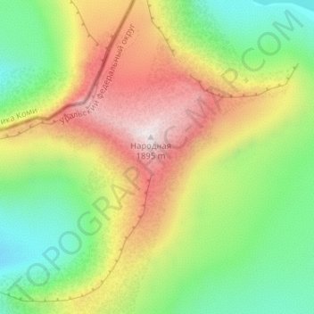
Nombre: Mapa topográfico Ural Mountains, altitud, relieve.
Altitud media: 1.435 m
Altitud mínima: 1.101 m
Altitud máxima: 1.893 m
The Ural Mountains (/ˈjʊərəl/ YOOR-əl; Russian: Ура́льские го́ры, tr. Uralskiye gory, IPA: [ʊˈralʲskʲɪjə ˈɡorɨ]; Bashkir: Урал тауҙары) or simply the Urals, are a mountain range in Eurasia that runs north-south mostly through Russia, from the coast of the Arctic Ocean to the river Ural and northwestern Kazakhstan. The mountain range forms part of the conventional boundary between the regions of Europe and Asia. Vaygach Island and the islands of Novaya Zemlya form a further continuation of the chain to the north into the Arctic Ocean. The average altitudes of the Urals are around 1,000–1,300 metres (3,300–4,300 ft), the highest point being Mount Narodnaya, which reaches a height of 1,894 metres (6,214 ft).
Otros mapas topográficos
Haga clic en un mapa para ver su topografía, su altitud y su relieve.
Хурумпауль
Russia > Khanty-Mansiysk Autonomous Okrug – Ugra > Beryozovsky District
Хурумпауль, сельское поселение Саранпауль, Beryozovsky District, Khanty-Mansiysk Autonomous Okrug – Ugra, Ural Federal District, Russia
Altitud media: 21 m
Сохсъя
Russia > Khanty-Mansiysk Autonomous Okrug – Ugra > Beryozovsky District
Сохсъя, Beryozovsky District, Khanty-Mansiysk Autonomous Okrug – Ugra, Ural Federal District, Russia
Altitud media: 30 m
Mount Narodnaya
Russia > Khanty-Mansiysk Autonomous Okrug – Ugra > Beryozovsky District
Mount Narodnaya, Beryozovsky District, Khanty-Mansiysk Autonomous Okrug – Ugra, Ural Federal District, Russia
Altitud media: 1.437 m