
Mapa topográfico Isle Royale National Park
Mapa interactivo
Haga clic en el mapa para ver la altitud.
Acerca de este mapa
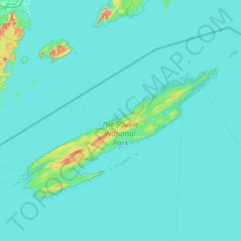
Nombre: Mapa topográfico Isle Royale National Park, altitud, relieve.
Altitud media: 189 m
Altitud mínima: 176 m
Altitud máxima: 550 m
Otros mapas topográficos
Haga clic en un mapa para ver su topografía, su altitud y su relieve.
Eagle Harbor Township
United States > Michigan > Keweenaw County
Eagle Harbor Township, Keweenaw County, Michigan, United States
Altitud media: 190 m
Mohawk
United States > Michigan > Keweenaw County
Mohawk, Allouez Township, Keweenaw County, Michigan, 49901, United States
Altitud media: 300 m
Eagle Harbor
United States > Michigan > Keweenaw County
Eagle Harbor, Eagle Harbor Township, Keweenaw County, Michigan, United States
Altitud media: 200 m
Allouez
United States > Michigan > Keweenaw County
Allouez, Allouez Township, Keweenaw County, Michigan, 49805, United States
Altitud media: 301 m
Isle Royale
United States > Michigan > Keweenaw County
Isle Royale, Keweenaw County, Michigan, United States
Altitud media: 190 m
Gay
United States > Michigan > Keweenaw County > Gay
Gay, Sherman Township, Keweenaw County, Michigan, United States
Altitud media: 188 m
Copper Harbor
United States > Michigan > Keweenaw County
Copper Harbor, Grant Township, Keweenaw County, Michigan, 49918, United States
Altitud media: 220 m