
Mapa topográfico Lake Greeson
Mapa interactivo
Haga clic en el mapa para ver la altitud.
Acerca de este mapa
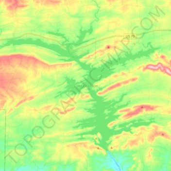
Nombre: Mapa topográfico Lake Greeson, altitud, relieve.
Lugar: Lake Greeson, Pike County, Arkansas, 71950, United States (34.14818 -93.83704 34.26039 -93.66063)
Altitud media: 195 m
Altitud mínima: 122 m
Altitud máxima: 304 m
Otros mapas topográficos
Haga clic en un mapa para ver su topografía, su altitud y su relieve.
Crater of Diamonds State Park
United States > Arkansas > Pike County > Murfreesboro > Kimberley
Crater of Diamonds State Park, Kimberley, Murfreesboro, Pike County, Arkansas, 71958, United States
Altitud media: 106 m
Little Missouri River
United States > Arkansas > Pike County
Little Missouri River, Pike County, Arkansas, 71958, United States
Altitud media: 159 m
Antoine
United States > Arkansas > Pike County
Antoine, Pike County, Arkansas, United States
Altitud media: 90 m
Glenwood
United States > Arkansas > Pike County > Glenwood
Glenwood, Pike County, Arkansas, United States
Altitud media: 193 m
Delight
United States > Arkansas > Pike County > Delight
Delight, Pike County, Arkansas, 71940, United States
Altitud media: 119 m
Murfreesboro
United States > Arkansas > Pike County
Murfreesboro, Pike County, Arkansas, 71958, United States
Altitud media: 114 m