
Mapa topográfico Bangkok
Mapa interactivo
Haga clic en el mapa para ver la altitud.
Acerca de este mapa
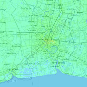
Nombre: Mapa topográfico Bangkok, altitud, relieve.
Lugar: Bangkok, Phra Nakhon District, Bangkok, 10200, Thailand (13.49342 100.32788 13.95519 100.93844)
Altitud media: 3 m
Altitud mínima: -12 m
Altitud máxima: 37 m
Bangkok is in the Chao Phraya River delta in Thailand's central plain. The river meanders through the city in a southerly direction, emptying into the Gulf of Thailand approximately 25 kilometres (16 mi) south of city centre. The area is flat and low-lying, with an average elevation of 1.5 metres (4 ft 11 in) above sea level. Most of the area was originally swampland, which was gradually drained and irrigated for agriculture by the construction of canals (khlong) which took place from the 16th to 19th centuries. The course of the river as it flows through Bangkok has been modified by the construction of several shortcut canals.
Otros mapas topográficos
Haga clic en un mapa para ver su topografía, su altitud y su relieve.
Benchakitti Park
Benchakitti Park, Khlong Toei District, Bangkok, Thailand
Altitud media: 9 m
Sanam Luang
Sanam Luang, Phra Nakhon District, Bangkok, 10200, Thailand
Altitud media: 7 m
Bang Sue District
Bang Sue District, Bangkok, 10800, Thailand
Altitud media: 5 m
Vadhana District
Vadhana District, Bangkok, 10110, Thailand
Altitud media: 7 m
Khlong Toei District
Khlong Toei District, Bangkok, Thailand
Altitud media: 7 m
Bang Khun Thian District
Bang Khun Thian District, Bangkok, 10150, Thailand
Altitud media: 2 m
Lumphini Park
Lumphini Park, Pathum Wan District, Bangkok, 10330, Thailand
Altitud media: 9 m
Bird Island
Bird Island, Bangkok, Dusit District, Bangkok, 10300, Thailand
Altitud media: 7 m
Dao Khanong River
Dao Khanong River, Bangkok, Rat Burana District, Bangkok, 10140, Thailand
Altitud media: 6 m