
Mapa topográfico Glanmire
Mapa interactivo
Haga clic en el mapa para ver la altitud.
Acerca de este mapa
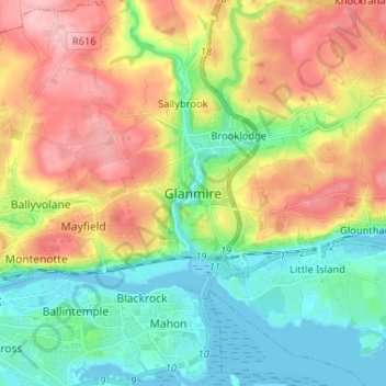
Nombre: Mapa topográfico Glanmire, altitud, relieve.
Lugar: Glanmire, County Cork, Munster, T45 X924, Ireland (51.87923 -8.43598 51.95923 -8.35598)
Altitud media: 58 m
Altitud mínima: -3 m
Altitud máxima: 143 m
Otros mapas topográficos
Haga clic en un mapa para ver su topografía, su altitud y su relieve.
Ballincollig
Ireland > County Cork > Cork
Ballincollig, Cork, County Cork, Munster, P31 TW88, Ireland
Altitud media: 62 m
Inchigeelagh
Inchigeelagh, Municipal District of Macroom, County Cork, Munster, P12 W864, Ireland
Altitud media: 135 m
Knockawaddra
Knockawaddra, Ballingurteen ED, West Cork, County Cork, Munster, Ireland
Altitud media: 154 m
Killeagh
Killeagh, The Municipal District of East Cork, County Cork, Munster, P36 KN61, Ireland
Altitud media: 32 m
Gortroe
Gortroe, The Municipal District of Fermoy, County Cork, Munster, P61 TD96, Ireland
Altitud media: 120 m
Lyre
Lyre, Tincoora, The Municipal District of Kanturk-Mallow, County Cork, Munster, Ireland
Altitud media: 214 m
Coolmore Cross
Coolmore Cross, Carrigaline ED, Municipal District of Carrigaline, County Cork, Munster, P43 DA03, Ireland
Altitud media: 21 m
Water-rock
Water-rock, Carrigtohill ED, Municipal District of Cobh, County Cork, Munster, Ireland
Altitud media: 22 m
Castletownroche
Castletownroche, The Municipal District of Fermoy, County Cork, Munster, P51 K064, Ireland
Altitud media: 67 m
Dundareirke
Dundareirke, Kilnamartery, Municipal District of Macroom, County Cork, Munster, Ireland
Altitud media: 116 m
Castlemartyr
Castlemartyr, The Municipal District of East Cork, County Cork, Munster, Ireland
Altitud media: 14 m
Ballincollig Regional Park
Ireland > County Cork > Cork
Ballincollig Regional Park, West Village, Carrigrohane Beg ED, Cork, County Cork, Munster, Ireland
Altitud media: 55 m
Berrings
Berrings, Dripsey, Municipal District of Macroom, County Cork, Munster, Ireland
Altitud media: 113 m
Moneyreague
Moneyreague, Coolmountain ED, West Cork, County Cork, Munster, Ireland
Altitud media: 122 m
Waterfall
Waterfall, Inishkenny, Municipal District of Carrigaline, County Cork, Munster, T12 CYF2, Ireland
Altitud media: 96 m
Macroom
Macroom, Municipal District of Macroom, County Cork, Munster, Ireland
Altitud media: 110 m
Ballymore
Ballymore, Cobh Rural ED, Municipal District of Cobh, County Cork, Munster, Ireland
Altitud media: 40 m
Aghabullogue
Aghabullogue, Municipal District of Macroom, County Cork, Munster, P12 DY92, Ireland
Altitud media: 133 m
Liscahane Beg
Liscahane Beg, Kinsale Rural, The Municipal District of Bandon-Kinsale, County Cork, Munster, Ireland
Altitud media: 47 m
Kilmurry
Kilmurry, Municipal District of Macroom, County Cork, Munster, P14 R940, Ireland
Altitud media: 122 m
Mallow
Mallow, The Municipal District of Kanturk-Mallow, County Cork, Munster, Ireland
Altitud media: 77 m
Baltimore
Baltimore, West Cork, County Cork, Munster, P81 F623, Ireland
Altitud media: 23 m
Kilmacsimon
Kilmacsimon, Knockroe, The Municipal District of Bandon-Kinsale, County Cork, Munster, Ireland
Altitud media: 50 m
Timoleague
Timoleague, The Municipal District of Bandon-Kinsale, County Cork, Munster, P72 DX23, Ireland
Altitud media: 48 m
Dromsarane
Dromsarane, Castlemartyr ED, The Municipal District of East Cork, County Cork, Munster, Ireland
Altitud media: 54 m
Glounthaune
Glounthaune, Municipal District of Cobh, County Cork, Munster, T45 V201, Ireland
Altitud media: 52 m
Tawnies Lower
Tawnies Lower, Clonakilty Urban ED, West Cork, County Cork, Munster, Ireland
Altitud media: 46 m
Ladysbridge
Ladysbridge, Ightermurragh, The Municipal District of East Cork, County Cork, Munster, P25 X820, Ireland
Altitud media: 30 m
Ringcurran
Ringcurran, The Municipal District of Bandon-Kinsale, County Cork, Munster, Ireland
Altitud media: 60 m
Ardamadane
Ireland > County Cork > Cork
Ardamadane, Blarney ED, Cork, County Cork, Munster, Ireland
Altitud media: 92 m
Doneraile
Doneraile, The Municipal District of Fermoy, County Cork, Munster, Ireland
Altitud media: 85 m
Kilmaclenine
Kilmaclenine, The Municipal District of Kanturk-Mallow, County Cork, Munster, Ireland
Altitud media: 109 m
Dunbulloge
Dunbulloge, Killeagh, Municipal District of Cobh, County Cork, Munster, Ireland
Altitud media: 117 m
Ringrone
Ringrone, Kinsale Rural, The Municipal District of Bandon-Kinsale, County Cork, Munster, Ireland
Altitud media: 41 m
Monkstown
Ireland > County Cork > Municipal District of Carrigaline
Monkstown, Municipal District of Carrigaline, County Cork, Munster, T12 KT5N, Ireland
Altitud media: 44 m
Aghada
Aghada, Corkbeg ED, The Municipal District of East Cork, County Cork, Munster, P25 HX04, Ireland
Altitud media: 25 m
Cloghmacow
Cloghmacow, Warrenscourt, Municipal District of Macroom, County Cork, Munster, Ireland
Altitud media: 118 m
Roughgrove East
Roughgrove East, Kilbrogan, The Municipal District of Bandon-Kinsale, County Cork, Munster, Ireland
Altitud media: 105 m
Lissanly
Lissanly, Cloyne ED, The Municipal District of East Cork, County Cork, Munster, Ireland
Altitud media: 34 m
Ballygarvan
Ballygarvan, Municipal District of Carrigaline, County Cork, Munster, T12 RR02, Ireland
Altitud media: 70 m
Killumney
Killumney, Ballygroman ED, Municipal District of Macroom, County Cork, Munster, Ireland
Altitud media: 79 m
Coolflugh
Ireland > County Cork > Cork
Coolflugh, Matehy, Cork, County Cork, Munster, T23 YX51, Ireland
Altitud media: 71 m
Lyre (Barry)
Lyre (Barry), Gortnaskehy, The Municipal District of Fermoy, County Cork, Munster, Ireland
Altitud media: 192 m
Banteer
Banteer, The Municipal District of Kanturk-Mallow, County Cork, Munster, Ireland
Altitud media: 85 m
Scartlea Upper
Scartlea Upper, Cloyne ED, The Municipal District of East Cork, County Cork, Munster, Ireland
Altitud media: 54 m
Halfway
Halfway, Dunderrow, Municipal District of Carrigaline, County Cork, Munster, T12 KT99, Ireland
Altitud media: 96 m