
Mapa topográfico Tiruvannamalai
Mapa interactivo
Haga clic en el mapa para ver la altitud.
Acerca de este mapa
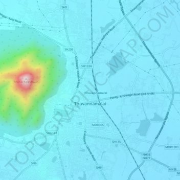
Nombre: Mapa topográfico Tiruvannamalai, altitud, relieve.
Lugar: Tiruvannamalai, Tiruvanamalai District, Tamil Nadu, India (12.21239 79.05339 12.26409 79.08889)
Altitud media: 202 m
Altitud mínima: 149 m
Altitud máxima: 788 m
Located on the foothills of Annamalai hills, Tiruvannamalai has been ruled by the Pallavas, the Medieval Cholas, the Later Cholas, Hoysalas, the Vijayanagar Empire, the Carnatic kingdom, Tipu Sultan, and the British. It served as the capital of the Hoysalas. The town is built around the Annamalaiyar Temple like other Nayak capitals. Tiruvannamalai is administered by a special-grade a municipality constituted in 1886. Tiruvannamalai has an average elevation of 200 metres (660 ft) and experiences a hot and humid climate. Being a pilgrimage town, most of the people are employed in the tertiary sector. There are 25 elementary schools, nine high schools, 18 higher secondary schools, four arts & science colleges, one government medical college and four engineering colleges in the town.